» Back to: » Planning home » Community Based Planning Home » Great Seneca Science Corridor
Great Seneca Science Corridor Master Plan
(formerly Gaithersburg West Master Plan)
View the approved and adopted Great Seneca Science Corridor Master Plan (23 MB).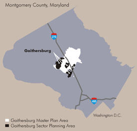
A 21st-century blueprint for the Shady Grove Life Sciences Center was established with the approval of the Great Seneca Science Corridor Master Plan by the County Council on May 4, 2010.
Home to a major hospital, academic institutions, and private biotechnology companies, the Life Sciences Center (LSC) serves as the County's premier location for and has the largest concentration of advanced technology accompanies. Shady Grove Adventist Hospital, Johns Hopkins University-Montgomery County Campus (JHU-MCC), the Universities at Shady Grove, and biotechnology companies such as Human Genome Sciences, BioReliance, and the J. Craig Venter Institute are all located in the Life Sciences Center. The federal government's General Services Administration recently selected the JHU-MCC site for the National Cancer Institute's consolidated headquarters.
News and Events
There are no events scheduled. Please check back periodically for any updates.
Plan Implementation
Visit our Life Sciences Center monitoring page to track the status of development staging in the area, including information on the LSC Loop Trail and Biennial Master Plan Monitoring Report.
In June 2011, the Planning Board approved implementation guidelines for GSSC. The guidelines (500 kb) contain procedures for coordinating, staging, and monitoring implementation of recommendations for the Life Sciences Center. As spelled out in the GSSC master plan, the guidelines establish a development staging plan, which times the delivery of infrastructure and amenities with development. Among other things, the plan requires the creation of a biennial monitoring program to track development and staging triggers at each stage of the LSC’s development. The guidelines should be used by developers in the LSC, as well as citizens who want to know what is being planned in their neighborhood.
Master Plan Design Guidelines
View the design guidelines (5.3MB) for the Great Seneca Science Corridor Master Plan.
View the June 2010 staff presentation (4.5MB) to the Planning Board
Design Guidelines help implement the recommendations in approved and adopted master plans or sector plans. They illustrate how Plan recommendations and principles might be met, and encourage applicants to propose designs that create an attractive and successful public realm. Design Guidelines are approved by the Planning Board for use by planning staff in developing and evaluating proposed building projects and other applications. With the exception of street standards and other specific Master Plan recommendations, the guidelines do not mandate specific forms and locations for buildings and open space.
Master Plan Implementation Advisory Committee
The Planning Board established an advisory committee of property owners, residents, and interested groups (including adjacent neighborhoods in Gaithersburg and Rockville), with representation from the Executive Branch, the City of Rockville, and the City of Gaithersburg that are stakeholders in the redevelopment of the Plan area. The committee's responsibilities include monitoring the plan recommendations, monitoring the Capital Improvement Program and Growth Policy, and recommending action by the Planning Board and County Council to address issues that may arise, including, but not limited to, community impacts and design, and the status and location of public facilities and open space.
Meeting schedule
(meetings held at 7:30 p.m. in the Camille Kendall Academic Center (Building III), Universities at Shady Grove, unless otherwise noted)
Upcoming
Past meetings
- August 23, 2016 (postponed)
- June 23, 2016 (postponed)
- April 12, 2016 (postponed)
- December 8, 2015
NEW! View agenda; Bicycle Master Plan Update; Biomed Sciences and Engineering Building; LSC Loop Update
- November 10, 2015 (postponed)
- October 13, 2015 (postponed)
- September 8, 2015 (postponed)
- July 14, 2015 (postponed)
- June 23, 2015
NEW! View agenda; Draft 15% Design LSC Loop; Draft Implementation and Funding Strategy
- May 26, 2015
View agenda; View LSC Loop presentation
- March 26, 2015
View Bike Presentation; View Loop Trail Presentation
- March 10, 2015 (postponed)
- February 10, 2015
View agenda; View presentation
- January 13, 2015 (cancelled)
- November 18, 2014
View agenda
- October 8, 2013
View agenda (43 KB)
View the presentation (1 MB)
- May 13, 2013
- March 12, 2013
View agenda (145 KB)
- February 12, 2013
- January 8, 2013
- November 13, 2012
View presentations:
- October 9, 2012
View agenda(191 KB)
View presentations
:
- September 1, 2012
View agenda(191 KB)
- May 15, 2012
- April 17, 2012
View Pipeline Development presentation (1.8 MB)
- March 20, 2012
View
agenda (153 KB)
- January 17, 2012
View agenda (188 KB)
View Development Review presentation (941 KB)
- November 15, 2011
View agenda(154 KB)
View transportation presentation (2.3 MB)
View DOT annual commuter survey presentation(1.3 MB)
- October 18, 2011
View agenda (155 KB)
View Shady Grove Adventist Hospital Aquilino Cancer Center presentation (2.3 MB)
View committee's Mallory Square Sketch Plan memo(61 KB)
- September 20, 2011
View agenda (154 KB)
- July 19, 2011
View the Development Review Presentation (pdf, 2.7 MB)
IAC Responsibilities (pdf, 17 7KB)
IAC Decision-making Process (pdf, 242 KB)
GSSC Implementation Advisory Committee Membership Roster (pdf, 165 KB)
- June 21, 2011
View staff's presentation (200 KB)
- May 17, 2011
View agenda (150 KB)
View Adventist Health Care presentation (3.8 MB)
View GSSC urban design guideline presentation (4.7 MB)
- April 26, 2011
- March 15, 2011
View the staff presentation (900 KB)
View Johns Hopkins University presentations about:
Shady Grove Life Sciences Center Timeline
- 1971: The 1971 Gaithersburg Vicinity Master Plan endorses the County proposal for a future Montgomery County Medical Center complex west of Shady Grove Road
- 1973:
The Public Service Training Academy locates west of Great Seneca Highway
- 1976:
County conveys land to the State for the Regional Institute for Children and Adolescents (RICA) and the Noyes Institute (at Great Seneca Highway and Key West Avenue)
- 1979:
Shady Grove Adventist Hospital opens
- 1984:
County conveys land (south of Darnestown Road at Shady Grove Road) to the University of Maryland
- 1985:
The 1985 Gaithersburg Vicinity Master Plan expands the Medical Center concept to a "Research and Development Village"
- 1986:
County Council approves the Shady Grove Life Sciences Center Development Plan to guide development of the County-owned area
- 1986:
County conveys land to Johns Hopkins University (JHU) for its Montgomery County Campus (at Key West Avenue and Medical Center Drive)
- 1987:
Center for Advanced Research in Biotechnology (CARB) opens at the University of Maryland Shady Grove Campus
- 1989:
Johns Hopkins University purchases the 138-acre Belward Farm
- 1990:
The 1990 Shady Grove Study Area Master Plan expands the vision for the "Research & Development Village," retains sites in the Life Sciences Center for this purpose, and proposes mixed-use residential neighborhoods at the King Farm, Crown Farm, Thomas Farm, and Traville
- 1996:
JHU receives approval for 1.8 million square feet of development on the Belward property
- 2000:
The Universities at Shady Grove, an innovative program offering undergraduate and graduate degrees from eight Maryland public universities at Shady Grove campus, is created
- 2005:
JHU begins to rethink their original plans for Belward
- 2007:
The Planning Department initiates the Gaithersburg West Master Plan, focusing on the Life Sciences Center, and working in collaboration with JHU, Adventist Hospital, the Universities at Shady Grove, LSC property owners, and area citizens and residents.
- 2010: The County Council approves the GSSC Master Plan and associated Sectional Map Amendment.
Staff contact
Patrick Butler
301-495-4561
Patrick.Butler@montgomeryplanning.org
Last updated: September 12, 2017
back to top