West Cedar Shared-Use Path
Mandatory Referral No. MR2010812
Description
 Click for a larger view
 The project would replace the existing four-foot-wide sidewalk on the south side of West Cedar Lane between MD187 and MD355 with an eight-foot-wide shared use path, generally separated from the curb by a two-foot-wide grass strip. In three areas (totaling about 760’ in length), the path would be constructed adjacent to the curb.
The proposed shared use path would tie into path segments on both MD187 and MD355 being constructed by the State Highway Administration (SHA) as part of their intersection improvements undertaken in response to the relocation of Walter Reed Hospital to the National Naval Medical Center campus in Bethesda.
Recommendation
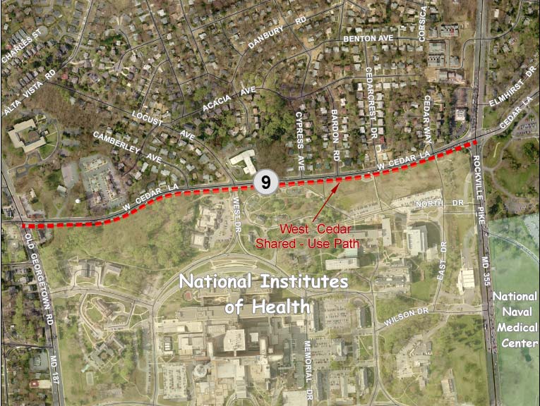
Staff recommends that the Board approve the proposed project (see Attachment 1: Vicinity Map) with the following comments:
- Provide an off-road bike facility that meets current standards for facility width and clear zones. To achieve that goal, consider eliminating the parking lane on the north side of West Cedar Lane, moving the curb on the south side and narrowing the pavement by six feet to increase:
- the buffer width for the path from two feet to three feet
- the path width from eight feet to ten feet, and
- the minimum distance between the path and the utility poles from zero feet to three feet
- If the above is not feasible, provide a variable offset or meandering alignment of the proposed path to achieve a three-foot-wide minimum buffer between the proposed shared use path and the curb outside the immediate area of the utility poles.
- Provide handicap ramps so that the proposed path is ADA-accessible at all intersections within the project limits.
- Provide additional lighting fixtures for the shared use path as necessary to meet AASHTO lighting standards.
- Continue to coordinate with SHA to ensure that your plans reflect the latest designs for their BRAC intersection projects at the eastern and western project limits.
Findings
Master Plan
West Cedar Lane is classified as an Arterial road in the Bethesda-Chevy Chase Master Plan, which recommends that it have a right-of-way width of 80 feet and a pavement width of 48 feet. No specific number of travel lanes is recommended. The existing pavement width is approximately 44 feet, less than the recommended 48 feet, but no change is proposed.
The 2005 Countywide Bikeways Functional Master Plan recommends that bike accommodation on West Cedar Lane be via a shared-use path and a signed shared roadway. This project proposes to have a shared use path on the south side, consistent with the recommended off-road accommodation. No signing for on-road bike use exists or is proposed.
The proposed path is also consistent with the Bethesda/Chevy Chase Plan recommendation for the “expansion of pedestrian paths and bikeways to form a network linking residential neighborhood with public facilities” (p.102). Further, the Plan also recommends improving pedestrian safety along major highways and arterials, such as West Cedar Lane (p.103).
American Association of State Highway and Transportation Officials (AASHTO)
The proposed path does not meet the AASHTO recommended width of ten feet.
The proposed path does not meet the AASHTO recommendation to be two feet wider where immediately adjacent to the roadway curb to provide a greater measure of pedestrian and bicyclist safety and comfort.
The proposed path does not meet the AASHTO recommendation to have a three-foot-wide offset to lateral obstructions, in this case, utility poles that are immediately behind the proposed path.
Some light fixtures exist on utility poles within the project limits but additional lighting is likely necessary to meet AASHTO standards for the proposed shared use path.
Road Code and Associated Executive Regulations
The proposed typical section does not conform to an approved County Standard. The path width of eight feet meets the minimum Road Code width for a shared use path. The landscape buffer between the curb and shared use path is less than the recommended 5-foot minimum width and in some cases, no buffer is proposed.
Americans with Disabilities Act (ADA)
There are six unsignalized public street intersections on West Cedar Lane within the project limits; however the proposed path would be handicapped accessible at only two of the intersections: West Drive/Locust Avenue and Cedar Crest Drive. The other four intersections would not meet ADA requirements.
Analysis
Bicyclist Accommodation
The proposed project would expand the existing four-foot-wide sidewalk to an eight-foot-wide shared use path between MD187 and MD355, providing a connection to the North Bethesda Trail along MD187, the trail along the MD355 frontage of NIH, and the trail along Cedar Lane between MD355 and Rock Creek Trail that will be improved by SHA and MCDOT in the near future as part of their response to the BRAC move (see Attachment 2).
We agree that locating the path adjacent to National Institutes of Health (NIH) is a better choice than placing the path on the northern side of West Cedar Lane where several residential driveways and public streets would interrupt the proposed path. The proposed location on the south side would form part of a continuous path around the NIH campus. The proposed facility would provide an improvement for off-road bicyclists, but we believe that some significant design improvements are warranted to provide sufficient path and clear zone widths.
Our primary concern is that insufficient width exists on the south side of the roadway to provide a path that has an adequate width, including clear zones to reduce shy distance and provide handlebar clearance. Generally, only 10’ of clearance exists between the roadway curb and PEPCO utility poles located approximately every 160’. While the staff and Planning Board supported a similar shared-use path along Jones Bridge Road with a 10’ width for locations adjacent to the curb (mandatory referral MR2010809 on July 15), staff finds the 10’ distance is undesirable along Cedar Lane due to:
- The use of the adjacent curb lane for parking rather than travel, introducing concerns about car door swings,
- The obstructions created by the utility poles adjacent to the back side of the proposed path, and
- The support for a wider path by the adjacent property owner.
NIH staff recommended a ten-foot-wide path, which is the current AASHTO standard, rather than the proposed eight-foot-wide path. NIH staff also recommended that a three-foot-wide offset from the curb be provided for the path, rather than the two-foot-wide buffer proposed. We agree with both of these recommendations. MCDOT responded that a wider path and buffer would require relocation of the utility poles that in many cases are immediately behind the proposed path.
We believe that the lack of adequate offsets from the roadway and the utility poles potentially compromises the path’s utility and raises a safety concern. In addition, three locations – totaling about 20% of the project length - would have the proposed eight-foot-wide path directly adjacent to the curb with no buffer:
- A 240-foot segment adjacent to the fire station
- A 305-foot segment west of the West Cedar Lane/West Drive/Locust Avenue intersection
- A 215-foot segment opposite Cypress Avenue
Curb-attached paths are generally a concern because a minimum offset of two feet is needed to avoid overhanging mirrors from passing vehicles and because users tend to shy away from the curb, reducing the effective width of the path. In this case, passing vehicles would not be a problem since the path is adjacent to a parking lane. However, since there is a continuous line of vehicles regularly parked along the south side of West Cedar Lane adjacent to NIH, overhanging mirrors from large parked vehicles could still be a problem.
Vehicle doors opening into the path are a larger concern though. (This problem is called “dooring” by bike professionals.) Bicyclists could be surprised by such an occurrence and collide with the door or with another user. The greatest concern about dooring is for those path segments that are immediately adjacent to the curb. But since a car door extends about 2’-6” or more from the side of the vehicle, the whole length of the project is potentially affected. Because of the steep slope that exists in some areas beyond the two-foot-wide graded shoulder on the back side of the proposed path, the possibility of avoiding a collision would be reduced.
An additional concern for the safety and comfort of bicyclists on the proposed path would be the presence of utility poles closer than the recommended three feet from the path - in many cases with no offset from the path. These lateral obstructions in the bikeway clear zone are potential hazards that cause users to shy away from them, reducing the effective width of the path.
The proposed typical section is a modified amalgam of two of the alternatives shown to the public in March 2010 (see Attachment 3). Option 1 showed an eight-foot-wide path at the curb with a two-foot-wide offset to the utility pole, and Option 3 showed an eight-foot-wide path at the curb with the utility pole embedded one foot into the path. Option 2 that moved almost two dozen utility poles was the only option that would achieve a path that meets current standards. In addition to the significant cost of moving the poles, the additional impacts to trees were also a consideration in MCDOT’s decision not to choose this option.
The proposed path abuts NIH, which has a large bike group (663 riders registered for Bike to Work Day this year); is near the Medical Center Metro Station, which has one the highest levels of bike usage in the Metrorail system; connects to a robust network of paths; and is intended to promote bike accessibility to NNMC, the site of the BRAC move in this area. All of these factors should promote building an excellent facility rather than a marginal one.
Consideration of Relocated South Curb
To achieve an excellent shared use path, more space is needed to accommodate wider offsets and a wider trail. As part of their initial planning, MCDOT considered eliminating the parking along the NIH frontage on the south side of West Cedar Lane, but rejected this concept because the parking is so well-used by contractors and other visitors to NIH. We recommend that MCDOT reconsider this concept but gain the additional space by moving the south side curb and removing the north side parking, which we find to be infrequently used and all the properties on the north side of the road have off-street parking. The lane striping on West Cedar Lane would have to be shifted accordingly.
Reallocating six feet of space in the typical section from the north side parking lane to the south side bike path would enable:
- The buffer width for the path to be increased from two feet to three feet
- The path width to be increased from eight feet to ten feet, and
- The minimum distance between the path and the utility poles to be increased from zero feet to three feet
We strongly recommend that MCDOT consider this alternative to achieve a bike facility that meets current standards. Pursuing this alternative would require additional community coordination (primarily regarding the acceptability of removing on-street parking from one side of the street), design efforts, and capital cost; but would result in a safer path free of obstructions in the bikeway clear zone. It would also achieve this objective by reallocating, rather than increasing, total impervious surface.
Variable Offset Alignment
If relocating the south curb is not feasible, a low-cost alternative for improving the proposed path would be to shift its alignment slightly between the utility poles to provide a minimum offset of three feet. A lesser offset would be provided at the utility poles, so the result of this variable offset proposal would be a very subtle meandering of the path alignment between obstructions. The utility poles are generally about 160 feet apart so the variation in the path alignment would be small but the concern with dooring would be greatly reduced. This would partially resolve the dooring concern, but the resulting facility would still have approximately 20 utility poles in the bikeway clear zone and would not meet the 10’ AASHTO width recommendation supported by NIH.
Under any concept under discussion, including those proposed by staff, on-road bicyclists would continue to share the roadway with drivers in lanes that are less than the desired width for most on-road bike routes. Bike activists have indicated to us that the existing conditions on West Cedar Lane are acceptable and that, as with the rest of the BRAC projects, the higher priority in the NIH/NNMC area should be on improving the off-road facilities.
Pedestrian Accommodation
Pedestrian accommodation would be improved by the widening of the existing four-foot sidewalk to an eight-foot shared use path. The width of the current four-foot sidewalk does not meet the ADA requirement for a passing space every two hundred feet for sidewalks that are less than five feet wide. The proposed path would eliminate that substandard condition.
As noted above, the proposed path would be ADA-accessible from only two of the six public street intersections on the north side of West Cedar Lane within the project limits: West Drive/Locust Avenue and Cedar Crest Drive. Of the remaining four intersections, one is a four-legged intersection that provides access to NIH (Cedar Way/East Drive), one is a tee intersection that has a bus stop (Cypress Avenue), and there are two additional tee intersections (Camberley Avenue and Bardon Road).
MD Vehicle Law establishes crosswalks at every public intersection and that pedestrians have the right-of-way at these intersections. Therefore, these intersections are required by ADA to be handicapped-accessible. We recommend that handicap ramps be provided to ensure that the proposed path and bus stops are accessible to everyone.
Lighting
We recommend that additional light fixtures be provided for the proposed path as necessary to achieve the lighting levels recommended by AASHTO.
Landscaping
The proposed project includes no landscaping as the buffer width is too small to accommodate any substantial planting material.
Environmental Guidelines
The project area contains environmental buffers, streams, other sensitive features. The property is within the Lower Rock Creek watershed, a USE I-P designation. The Countywide Stream Protection Strategy (CSPS) rates this watershed as fair to poor condition.
The project proposes no removal of forest but does have impacts on 0.02 acre of Stream Valley Buffer (SVB). The SVB impacts are necessary and unavoidable to achieve the design standards of creating the new pathway, and those impacts have been minimized to the greatest extent possible.
Forest Conservation
The project is exempt from submission of a forest conservation plan. A forest conservation exemption (#42010115E) was granted under the provisions of Section 22A-5(e) as “a state or county highway project”. The exemption was confirmed on February 12, 2010. While the project is exempt, the applicant is still required to minimize forest cutting, clearing, and loss of specimen trees under section 22A-9 of the County code. The applicant has minimized the limits of disturbance, minimizing the amount of forest clearing and impacts to large and specimen trees.
The applicant has submitted a tree save plan (TSP) in conjunction with the Mandatory Referral process to show how the impacts have been minimized and what stress reduction methods are being used to further minimize impacts on trees.
Tree Save
Thirty-eight (38) significant and specimen trees are impacted by this project, twenty-two (22) of which are specimen size. The proposed tree save plan does not propose the removal of any significant or specimen trees, however two trees have 40% or greater Critical Root Zone (CRZ) impacts. Tree ST-1 a 36” Tulip poplar has 50% CRZ impact and Tree ST-6 a 50” Pin oak has 41% CRZ impact. These two trees, based on the proposed impacts may not survive construction even though they are proposed to be retained by the applicant.
Coordination with SHA
Both ends of the project overlap with SHA’s BRAC intersection projects. MCDOT anticipates that this project will be built in advance of SHA’s projects. We recommend that MCDOT continue to coordinate with SHA to ensure that the shared use path project reflects SHA’s latest designs.
Status
The Planning Board approved the staff recommendations with comments on September 16, 2010 (pdf, 12KB) and transmitted the following comments to the Montgomery County Department of Transportation.
- Consider modifying the alignment of the proposed path to provide a wider buffer for the proposed shared use path outside the immediate area of the utility poles.
- Provide handicap ramps so that the proposed path is ADA-accessible at all intersections within the project limits.
- Continue to coordinate with the SHA to ensure that plans reflect the latest designs for their BRAC intersection projects at the eastern and western project limits.
- Provide additional lighting fixtures for the shared use path as necessary to meet AASHTO lighting standards.
View appendices detailing applicable master plans, policies, guidelines and other resources.
Date of last update: October 14, 2010