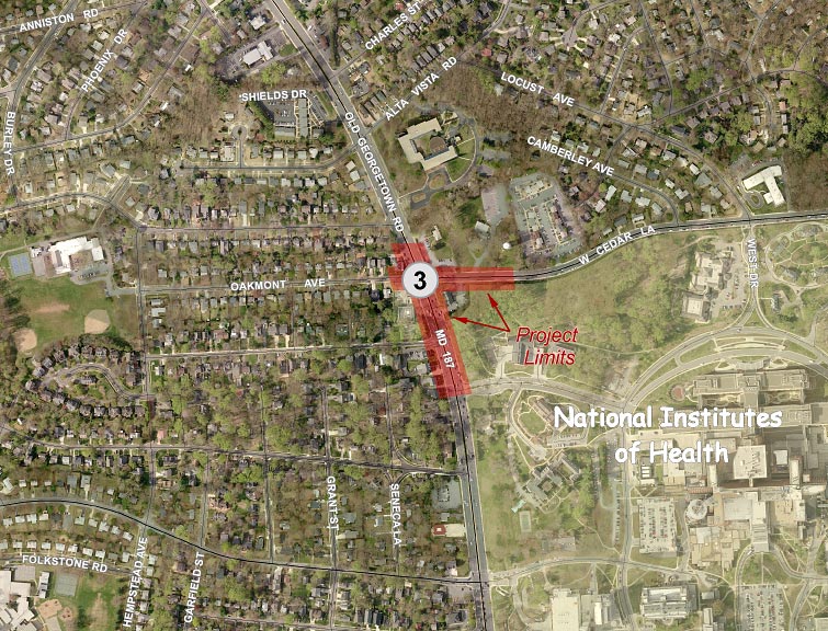
Old Georgetown Road (MD187)/West Cedar Lane/Oakmont Avenue Intersection
Description
 Click for a larger view
Mandatory Referral No. MR2010805
The project limits extend from Center Drive to Johnson Avenue along MD187, and about 400 feet along West Cedar Lane. The project would:
- Construct a westbound right turn lane on West Cedar Lane
- Construct a northbound right turn lane on MD187 south of West Cedar Lane
- Construct a shared use path along the east side of MD187 and the south side of West Cedar Lane
- Reconstruct the sidewalk along the west side of MD187 and the north side of West Cedar Lane adjacent to the curb
- Modify the existing driveway entrance to the small NIH facility in the southwest corner of the MD187/Oakmont Avenue intersection to allow exits only and widen the entrance of the same facility on MD187 to allow two-way traffic
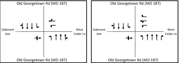
Existing Configuration Proposed Configuration
View the engineering drawings for this project.
Recommendations
General
- Make additional area bicycle and pedestrian improvements needed to provide safe and convenient access to the NIH and NNMC campuses within the overall BRAC traffic impact area rather than the limits of the individual intersection projects within that area.
- Revise the proposed handicap ramp designs to meet ADA Best Practices wherever possible, including locating sidewalks and paths behind handicap ramps at intersections to avoid unnecessary grade changes for handicapped persons.
- Widen proposed sidewalks and shared use paths by two feet where they are located adjacent to the curb.
- At intersections where SHA believes that a safe ADA-accessible crossing cannot be provided, we recommend that the intersections be signed to prohibit the crossing and to direct pedestrians to the safest crossing.
- Provide supporting documentation of any final decision not to provide crosswalks on all legs of signalized intersections.
- Evaluate the lighting along the roads covered by these projects for their adherence to current AASHTO lighting standards and upgrade and augment these facilities where needed.
- Continue to coordinate with MCDOT on their Countywide Bus Rapid Transit Study and consider the designation of additional through travel lanes as “diamond lanes” for restricted use by buses and high-occupancy vehicles during peak periods along the State highways covered by these projects.
- Consider providing a four-foot-wide smooth concrete panel as part of the proposed decorative crosswalks to accommodate persons with disabilities.
- Where large volumes of pedestrians and bikes are expected, consider making the crosswalks wider than 10 feet.
- Provide shade trees between the curb and sidewalk wherever possible. Major deciduous trees are recommended over flowering trees in the ROW to provide a better sense of scale on these wide roads. Utilize species of trees that can accommodate the pruning needed to accommodate overhead utilities.
- Impervious surfaces in the median should be avoided wherever possible in favor of landscaping. Four-foot-wide medians should be planted with liriope.
- Landscaping and streetscaping should be provided that ensures community compatibility; reflects the national importance of the National Institutes of Health, the National Naval Medical Center, and the Howard Hughes Medical Institute; and is compatible with the landscaping plans of those institutions.
- Work with our staff to achieve mutually acceptable revisions to landscaping plans for all four intersections within 60 days or prior to submission of Phase 3 for the MD185/Jones Bridge Road project.
- Provide responses to all other comments within 60 days.
Specific to Old Georgetown Road (MD 187)/West Cedar Lane/Oakmont Avenue
- Complete the North Bethesda Trail by replacing the existing sidewalk along the east side of MD187 with a eight-foot-wide minimum shared use path from Charles Street to Alta Vista Road and by extending the proposed path from Center Drive to Lincoln Street.
- Provide shade trees on both sides of the North Bethesda Trail extension along NIH’s frontage and provide additional planting materials to enhance this facility. Provide shade trees between the curb and sidewalk/path elsewhere on this project.
- Construct the proposed sidewalk on the west side of MD187 five feet from the curb, except in the immediate vicinity of the northeast corner of the Walter Johnson House.
- Reconsider providing a six-foot-wide pedestrian refuge on the south leg of MD187 at West Cedar Lane/Oakmont Avenue.
- Provide a design treatment for the proposed sidewalk at the Walter Johnson House that ensures the structural stability of the house and is attractive.
- At the proposed MD187 median cut-through for the fire station, use the same gray color for the concrete as the rest of the ashlar slate median treatment.
Findings
Master Plan
Old Georgetown Road (MD187): The project is consistent with the Master Plan in regard to the number of lanes and the provision of a shared-use path on the east side of the roadway. The project is not consistent with the Master Plan recommendation for trees in the median and along both sides of the road.
West Cedar Lane: The proposed pavement width exceeds the recommended 48 feet for a distance of about 300 feet east of the MD187 intersection. The proposed shared-use path is consistent with the Master Plan.
Oakmont Avenue: The project is consistent with the Master Plan.
SHA’s Bicycle and Pedestrian Design Guidelines (MD187 only)
Sidewalk: Continuous sidewalks or shared use paths would be provided within the project limits.
On-road bike accommodation: The recommended bike lanes would not be provided, but the curb lanes would be slightly wider.
Landscape buffers: Landscape buffers would not be provided for about 600 feet of sidewalk and 100 feet of shared use path on the west and east sides of MD187, respectively.
American Association of State Highway and Transportation Officials (AASHTO)
Two segments of the proposed sidewalk on the west side of Old Georgetown Road (MD187), with a total length of about 600 feet, and a 100-foot length on West Cedar Lane do not meet the AASHTO recommendation to be two feet wider where immediately adjacent to the roadway curb to provide a greater measure of pedestrian safety and comfort.
AASHTO recommends that a pedestrian refuge island be considered where the crossing distance is greater than 60 feet. The crosswalk on the south leg of MD187 is approximately twice that length without a refuge and is therefore inconsistent with AASHTO’s guidance.
American with Disabilities Act (ADA)
The project meets the minimum accommodation required by ADA but does not meet ADA Best Practices in the following respects:
- Sidewalks and paths are located too close to the curb at intersection corners, requiring users to negotiate multiple ramps to travel along the sidewalk around the corner.
- Sidewalks are located too close to the curb at driveways, requiring users to negotiate multiple ramps to travel along the sidewalk.
Analysis
Roadway
Most of the east side of MD187 south of West Cedar Lane is bordered by NIH property, whose buildings are well set back from
the roadway, but there is a fire station at the southeast corner that poses a significant constraint to widening on the east side. Because the planned North Bethesda Trail is also on the east side of MD187, the widening is proposed on the west side of the road, shifting the centerline by a few feet.
The impacts of the proposed improvements on traffic operations are summarized below:
Location |
Without Improvements |
With Improvements |
||||
CLV |
Delay per vehicle AM/(PM) in seconds |
Weekday Peak Hour Delay (hours) |
CLV |
Delay per vehicle AM/(PM) in seconds |
Weekday Peak Hour Delay (hours) |
|
187/Cedar |
1323 / (1735) |
31 / (83) |
158 |
1183 / (1461) |
27 / (60) |
119 |
There is a possibility that SHA will implement Dynamic Lane Controls to govern the lane assignments, e.g. changing leftmost through lane to a second left turn lane, pending the results of similar improvements at MD355/Jones Bridge Road (see Attachment C.)
Pedestrian Accommodation
Pedestrians would be accommodated via a sidewalk and a shared use path on both MD187 and West Cedar Lane. The pedestrian accommodation on Oakmont Avenue is via a sidewalk on the south side of the road.
The proposed sidewalk on the west side of Old Georgetown Road (MD187) does not meet the ADA Best Practices described in Appendix E-1, since its location adjacent to the curb would require that it be warped at every driveway. All pedestrians would be required to negotiate fourteen ramps to travel along the sidewalk between Oakmont Avenue and Center Drive, an average of one ramp for every 46 feet of sidewalk. This would be an annoyance for an able-bodied pedestrian, but would require a lot more extra effort from people with a mobility disability and could create problems for those with visual impairments also. We recommend that the sidewalk be offset from the curb, and discuss additional reasons in Landscaping below.
As noted above, the crosswalk on the south leg of MD187 does not have a pedestrian refuge, but at 118 feet long, is almost twice the length (60’) at which one should be considered. Since left turns are proposed to be allowed from two lanes of West Cedar Lane (westbound to southbound), there is sufficient room to extend the median and provide a refuge without causing conflicts with trucks making the left from the center lane if the crosswalk is angled to be more perpendicular to the west curb of MD 187. We recommend that the refuge be reconsidered, even if it means restricting larger trucks to the center lane on West Cedar Lane. Guide striping for left turning vehicles could help address turning radius concerns.
Off-Road Bicyclist Accommodation
The North Bethesda Trail, shown in Appendix J-2, is an important component of the transportation system in the project area, connecting the Bethesda CBD and NIH to White Flint and providing a much-needed bike alternative to MD187 and MD355. Most of the trail already exists to the north of MD187, but it ends abruptly at MD187/Charles Street. As shown in the exhibit below, SHA proposes to build a 900-foot-long segment in the middle, but two gaps in the trail would still exist as only a five-foot-wide curb-attached sidewalk:
- A 320’ long gap between Charles Street and Alta Vista Road, and
- A 1900’ long gap between Center Drive and the Bethesda CBD (just south of Lincoln Street)
These gaps should be replaced with an eight- to 10-foot-wide trail offset from the road.
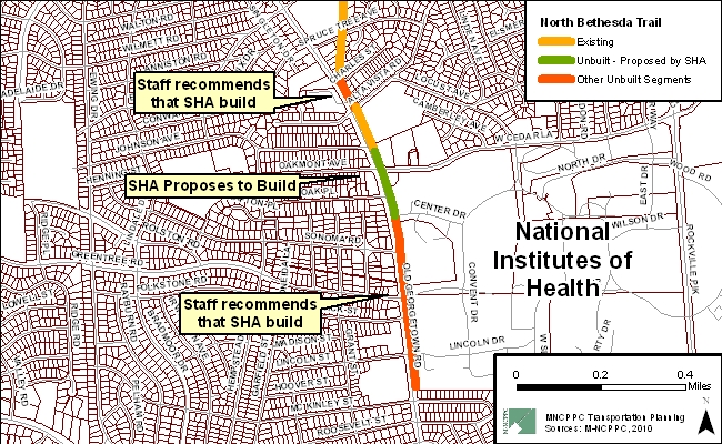
The northern, and shorter (about 320 feet), of the two gaps is between Charles Street and Alta Vista Road. Charles Street is the terminus of the standalone right-of-way for the trail that was formerly used for trolleys. The transition from the existing segment of the North Bethesda Trail to the sidewalk on MD187 at Charles Street is very abrupt. Riding on the narrow sidewalk directly adjacent to large volumes of fast-moving traffic feels very unsafe and the sense of continuity of the trail is lost. There appears to be adequate right-of-way to construct the path in this segment since there is about 43 feet of space between the curb and property line at the northern end and 12 feet at the southern end. All three of the properties on this block are medical offices.
A 500-foot-long segment of trail exists in front of the American College of Cardiology Foundation (ACCF) at 9111 Old Georgetown Road, just south of Alta Vista Road, but farther south only a curb-attached sidewalk exists.
SHA proposes to construct the trail within their limits of work for the intersection project between ACCF and Center Drive, the northernmost entrance to the NIH campus, a distance of about 900 feet. The southern, 1,900-foot-long, gap would remain between Center Drive and just south of Lincoln Street, from which point an existing path continues around the southern perimeter of the campus and ties into Battery Lane and the Woodmont Triangle. MCDOT has developed a conceptual design for this segment and shared it with SHA.
The North Bethesda Trail is one of the county’s major bicycle facilities, on which we have spent millions of dollars to construct bridges to carry the trail over the Capital Beltway and I-270. The success of NNMC’s Transportation Management Plan (TMP), provided in Appendix B-1, is dependent on getting its employees to commute to work by other than SOV. The Navy is working on creating a bike club similar to NIH’s very successful model to encourage bike use and we need good bike facilities for them to use. The North Bethesda Trail is one of the most important facilities in this area and in Montgomery County.
In addition, a good bike facility along Old Georgetown Road should encourage more use by NIH employees as well as others in the Bethesda area, freeing up some capacity that could offset the impacts of the BRAC move. We recommend that SHA construct the two missing segments of the North Bethesda Trail
Landscaping
The Master Plan recommends trees on both sides of Old Georgetown Road between the curb and sidewalk/path and in the median, but the proposed project has none. Very few shade trees are proposed and all are behind the sidewalk/path. Five ornamental trees are proposed in the median.
While the width of the landscape buffer is not ideal, there is sufficient room to plant shade trees between the curb and path on the east side of MD187; we recommend that this be done. As noted above, the proposed location of the sidewalk adjacent to the curb on the west side of MD187 would create a poor facility for handicapped persons even if it meets the letter of the law. We recommend that the sidewalk be offset by five feet and that shade trees be planted in the resulting buffer area. While this would create a greater impact on private property, we believe that it would create a better buffer from this wide roadway, as well as providing a better frame for the road itself.
Our recommended southern extension of the North Bethesda Trail covers two large blocks (1900’ in total length) along NIH’s frontage between Center Drive and Lincoln Street. Between Center Drive and South Drive, there is generous space for trail and landscaping opportunities, as the setback between the existing curb and attached sidewalk and NIH’s fence generally exceeds 100 feet in width. Between South Drive and Lincoln Street, the setback to the fence is about fifty feet wide. Both areas offer ample room to construct the trail with trees and other plant materials on both sides of the trail.
In addition to this trail serving its transportation function, we believe that it will be an amenity for NIH employees and visitors. Most of the roadways impacted by the proposed projects would not achieve the level of streetscaping recommended in the Master Plan, described in Appendix A-1, because of space constraints, so we should take advantage of this opportunity along MD187 to offset the lack of landscaping elsewhere, as well as to mitigate the impacts of wider pavement areas and the loss of green areas around NIH’s perimeter.
We previously recommended to SHA that they use the same ashlar slate concrete texture on a MD187 median cut-through that is proposed to be provided for the fire station. Fire and Rescue commented that their response abilities are adversely affected by the rough surface. We recommend that the concrete at least be made the same color (gray) as the rest of the median treatment.
Environmental Guidelines
The project is within the Lower Rock Creek watershed, a USE I-P designation. The Countywide Stream Protection Strategy (CSPS) rates this watershed as poor.
The project has no direct impacts on streams, wetlands, or environmental buffers.
Forest Conservation
The project is exempt from submission of a forest conservation plan. The project is also exempt from submitting a forest conservation exemption (#42010206E) under Section 22A-5(f) of the County code. This section of the Code provides exemptions from submitting forest conservation plans as “a governmental project reviewed for forest conservation purposes by the State Department of Natural Resources under the Code of Maryland Regulations”. The exemption was confirmed on May 20, 2010.
Historic
There is one Master Plan historic property within the project limits, the Walter Johnson House, at the northwest corner of MD187 and Oakmont Avenue. Some minor grading work would be required. Because the house is situated at an angle to MD187 however, the back of the proposed sidewalk would be only about three feet from the corner of the porch, whose foundation is above the roadway. The sidewalk is already at the curb and cannot be moved but we recommend that SHA provide a design treatment that ensures the structural stability of the house and is attractive.
Park Impacts
This project has no impact on park property.
Status
- The Planning Board approved the staff recommendations with comments on July 22, 2010 (pdf, 207KB) and transmitted comments to the State Highway Administration.
- SHA responded with comments on October 22, 2010 (pdf, 535KB).
View appendices detailing applicable master plans, policies, guidelines and other resources.
Date of last update: Noember 16, 2010