Rockville Pike (MD 355) / West Cedar Lane / Cedar Lane Intersection
Mandatory Referral No. MR2010806
Description
 Click for a larger view
The project limits extend from Wilson Drive to Broad Brook Drive/Elsmere Avenue along MD355, about 850 feet along West Cedar Lane west of the MD355 intersection, and 1,050 feet along Cedar Lane east of the MD355 intersection. The project would:
- Construct an additional northbound lane on MD355 from North Wood Road to Locust Hill Road
- Convert the existing southbound MD355 right turn lane at West Cedar Lane to a through-right lane and construct an additional southbound through lane on MD355 from West Cedar Lane to Wilson Drive
- Construct an additional lane on both westbound Cedar Lane and eastbound West Cedar Lane to separate the functions of the current middle through-left lane, increasing the number of left lanes and through lanes to two each
- Remove the split-phase traffic signal operation at MD355/ Cedar Lane/West Cedar Lane Reconstruct and widen the shared use path on the west side of MD355 and replace the sidewalk on the south side of West Cedar Lane with a ten-foot-wide shared use path
- Construct a sidewalk on the east side of MD355 from Elmhirst Drive to Broad Brook Drive
- Construct a stormwater management facility on park property in the northeast quadrant of the MD355/Cedar Lane intersection
- Relocate the entrance to the Stone Ridge School about 200 feet south of its current location on MD355
- Install a half-signal at North Wood Road to stop northbound MD355 traffic while traffic is entering and exiting NNMC during AM peak hours
- Replace the existing culverts under the south leg of MD355 and the east leg of Cedar Lane at the intersection to meet the 100-year and 50-year storms, respectively
- Eliminate the free-right turn islands in the northwest, southwest and southeast corners of the MD355/Cedar Lane/West Cedar Lane intersection
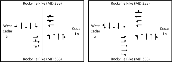
Existing Configuration Proposed Configuration
View the engineering drawings for this project.
Recommendations
General
- Make additional area bicycle and pedestrian improvements needed to provide safe and convenient access to the NIH and NNMC campuses within the overall BRAC traffic impact area rather than the limits of the individual intersection projects within that area.
- Revise the proposed handicap ramp designs to meet ADA Best Practices wherever possible, including locating sidewalks and paths behind handicap ramps at intersections to avoid unnecessary grade changes for handicapped persons.
- Widen proposed sidewalks and shared use paths by two feet where they are located adjacent to the curb.
- At intersections where SHA believes that a safe ADA-accessible crossing cannot be provided, we recommend that the intersections be signed to prohibit the crossing and to direct pedestrians to the safest crossing.
- Provide supporting documentation of any final decision not to provide crosswalks on all legs of signalized intersections.
- Evaluate the lighting along the roads covered by these projects for their adherence to current AASHTO lighting standards and upgrade and augment these facilities where needed.
- Continue to coordinate with MCDOT on their Countywide Bus Rapid Transit Study and consider the designation of additional through travel lanes as "diamond lanes" for restricted use by buses and high-occupancy vehicles during peak periods along the State highways covered by these projects.
- Consider providing a four-foot-wide smooth concrete panel as part of the proposed decorative crosswalks to accommodate persons with disabilities.
- Where large volumes of pedestrians and bikes are expected, consider making the crosswalks wider than ten feet.
- Provide shade trees between the curb and sidewalk wherever possible. Major deciduous trees are recommended over flowering trees in the ROW to provide a better sense of scale on these wide roads. Utilize species of trees that can accommodate the pruning needed to accommodate overhead utilities.
- Impervious surfaces in the median should be avoided wherever possible in favor of landscaping. Four-foot-wide medians should be planted with liriope.
- Landscaping and streetscaping should be provided that ensures community compatibility; reflects the national importance of the National Institutes of Health, the National Naval Medical Center, and the Howard Hughes Medical Institute; and is compatible with the landscaping plans of those institutions.
- Work with our staff to achieve mutually acceptable revisions to landscaping plans for all four intersections within 60 days or prior to submission of Phase 3 for the MD185/Jones Bridge Road project.
- Provide responses to all other comments within 60 days.
Specific to Rockville Pike (MD355)/Cedar Lane/West Cedar Lane
- Permit the PM peak operation of the proposed half-signal at North Wood Road only if there are no significant additional delays to MD 355 traffic.
- Provide a crosswalk on the south leg of MD355 at Cedar Lane/West Cedar Lane or provide a pedestrian-actuated signal to stop traffic in both directions at the proposed half-signal at North Wood Road. The bus stops on either side of MD355 at North Wood Road should be eliminated if no safe crossing is provided.
- Offset the proposed shared use path in the northeast and southwest quadrants of the MD355/ Cedar Lane/West Cedar Lane intersection, as well as the sidewalk in the southeast quadrant, so that they are outside the handicap ramp area. Provide a direct sidewalk connection between the sidewalks in the northwest quadrant so that the users do not have to traverse ramps to travel around the corner.
- Provide a continuous 10-foot-wide shared use path along the west side of MD355 between the West Cedar Lane and Jones Bridge Road intersections.
- Widen the landscape buffer adjacent to the proposed shared use path to eight to 11 feet along the west side of MD355 between Wilson Drive and the NIH Commercial Vehicle Inspection Facility. This can be accomplished by using a 4:1 slope between the path and curb without increasing impacts on NIH property.
- Develop a landscaping plan in conjunction with NIH and NNMC staff that includes provision of shade trees between the shared use path/sidewalk and curb along both sides of MD355 between the West Cedar Lane and Jones Bridge Road intersections.
- Provide a replacement for the monumental entrance to the Stone Ridge School that is acceptable to the school.
- Provide mitigation for the impacts to the park property in the northeast quadrant of the MD355/Cedar Lane intersection as follows:
- Design and construct the proposed stormwater facility as a well-landscaped amenity.
- Remove non-native invasive plants from the forested area downstream of the proposed pond site to improve the health and appearance of the streamside forest.
- Relocate the sanitary sewer line as close to the pond site as feasible to minimize the loss of quality forest.
- Reconstruct the shared use path along Cedar Lane from MD355 to Elmhirst Parkway to be offset from the roadway by a five-foot-wide (min.) landscape panel with street trees, outside the immediate area of the culvert under Cedar Lane, where possible while minimizing stream impacts. Where this cannot be accomplished, reconstruct the path to ten feet wide where adjacent to the curb and twelve feet wide where adjacent to both the curb and the culvert parapet.
- Obtain a signed Memorandum of Understanding from the Montgomery County Department of Parks prior to commencement of any construction related activities on parkland.
- Design and construct a hiker-biker trail bridge over Sligo Creek just downstream of Piney Branch Road by June 30, 2012. As a follow-up to our earlier agreement on SHA’s Piney Branch Road (MD320) project.
Findings
Master Plan
Rockville Pike (MD355): The project is consistent with the Master Plan in regard to the number of lanes and the provision of a shared-use path on the west side of the roadway, but inconsistent with the provision of landscaping.
West Cedar Lane: The proposed pavement width exceeds the recommended 48 feet for a distance of about 700 feet west of the MD355 intersection. The proposed shared-use path is consistent with the Master Plan.
Cedar Lane: The proposed pavement width exceeds the recommended 48 feet for a distance of about 750 feet east of the MD355 intersection. The proposed shared-use path is consistent with the Master Plan.
SHA’s Bicycle and Pedestrian Design Guidelines (MD355 only)
Intersection: No crosswalk would be provided on the south leg of the Cedar Lane/West Cedar Lane intersection.
Sidewalk: Continuous sidewalks or shared use paths would be provided within the project limits.
On-road bike accommodation: The recommended bike lanes would not be provided, but the curb lanes would be slightly wider.
Landscape buffers: Landscape buffers would be provided for all but short segments of the proposed shared use paths and sidewalks.
American Association of State Highway and Transportation Officials (AASHTO)
Two segments of proposed sidewalk on either side of MD355 just north of Cedar lane are adjacent to the curb, as is the short segment of sidewalk on West Cedar Lane just west of the intersection. These segments do not meet the AASHTO recommendation to be two feet wider where immediately adjacent to the roadway curb. A 170-foot-long segment of the proposed shared use path on the north side of Cedar Lane just east of the intersection similarly does not meet this recommendation.
AASHTO recommends that a pedestrian refuge island be considered where the crossing distance is greater than 60 feet. The crosswalk on West Cedar Lane is 88 feet; the crosswalk on Cedar Lane is 68 feet. Both exceed AASHTO’s guidance.
American with Disabilities Act (ADA)
The project meets the minimum accommodation required by ADA, but does not meet ADA Best Practices in that sidewalks and paths are located too close to the curb at intersection corners, requiring users to negotiate multiple ramps to travel along the sidewalk around the corner.
Analysis
Roadway
There are existing culverts under the south leg of MD355 and the east leg of Cedar Lane at this intersection that would be replaced in their entirety, enabling the widening of these roads while improving the ability of these culverts to pass larger storms. The culvert under MD355 acts somewhat as a constraint to further widening because its long length acts as a deterrent to fish passage.
This project would address the near-term traffic congestion, but the B-CC Master Plan recommends that a grade-separated interchange be built at this location. The impacts of the proposed improvements on traffic operations are summarized below:
Location |
Without Improvements |
With Improvements |
||||
CLV |
Delay per vehicle AM/(PM) in seconds |
Weekday Peak Hour Delay (hours) |
CLV |
Delay per vehicle AM/(PM) in seconds |
Weekday Peak Hour Delay (hours) |
|
355/Cedar |
1947 / (2084) |
136 / (168) |
617 |
1620 / (1645) |
55 / (52) |
217 |
A new half-signal is proposed at the intersection of MD355 and North Wood Road. The current proposal would stop northbound MD355 traffic during the AM peak while southbound left turns would be allowed to enter the North Wood gate. The Navy has requested that this signal operate during the PM peak also so that a double or triple right turn to northbound MD355 could be accommodated also so that traffic could more readily leave their campus. SHA has not yet made a decision on that request. The AM operation would not adversely affect overall traffic operations on MD355 because the half-signal would be stopping traffic in the non-peak direction. However, NIH has expressed a concern about this signal operating in the PM peak since peak direction traffic on MD355 would be adversely affected and, depending on the signal timing, traffic attempting to exit the NIH campus could be adversely affected also.
The NNMC Transportation Management Plan (TMP) is designed to reduce reliance on SOV travel during weekday peak periods. The TMP notes that due to patient care needs, only about 10% of NNMC employees are able to work a compressed work week. If NNMC staff’s work hours can be further staggered during the PM, greater upstream delays on MD355 might be avoided and AM peak traffic might also be alleviated. We recommend that SHA permit the PM peak operation of the half-signal only if there is no significant increase in delay to mainline MD 355 traffic.
Pedestrian Accommodation
Pedestrians would be accommodated on the sidewalk and shared use path on all three roadways: MD355, West Cedar Lane, and Cedar Lane.
As noted above, the crosswalks on the west and east legs of the intersection exceed AASHTO guidance for the provision of pedestrian refuges. The Cedar Lane leg is slightly over the recommended distance at 68 feet versus the AASHTO recommended 60 feet. The West Cedar Lane crosswalk is 88 feet long. While it would be desirable to have these pedestrian refuges, accommodating them would adversely affect the design of the stormwater management pond at the northeast corner of the intersection if the alignment of the through lanes is to be maintained. Therefore, we will forego a recommendation to provide these refuges.
The sidewalk in the northwest quadrant of the intersection along MD355 is proposed immediately adjacent to the roadway curb. AASHTO recommends that such sidewalks be two feet wider to provide a greater measure of pedestrian safety and comfort, but it would be necessary to increase the length of the two proposed retaining walls because of the adjacent tall slope. The walls in turn would trigger additional guidance that the sidewalk be widened by another two feet to account for the tendency of people to shy away from lateral constraints. Given the difficulties of construction at this location, we will forego a recommendation to widen the sidewalk beyond the standard five feet.
No crosswalk currently exists on the south leg of MD355 at Cedar/West Cedar and none is proposed. This creates a problem for pedestrians and off-road bicyclists travel on West Cedar Lane traveling to the NNMC campus since the nearest gate is at North Wood Road, where there is no existing or proposed crosswalk. These users would either have to cross the other three legs of this large intersection or travel more than 500 feet down to the signalized crosswalk at Wilson Lane and backtrack. We recommend that a crosswalk be provided on the south leg of MD355 at Cedar Lane/West Cedar Lane or that a pedestrian-actuated signal be provided to stop traffic in both directions at the proposed half-signal at North Wood Road. The latter option would have the advantage of allowing off-road bicyclists to stay on a shared use path until they are ready to cross MD355.
The proposed construction of a sidewalk on the east side of MD355 from Elmhirst Drive to Broad Brook Drive will improve general pedestrian accessibility and accessibility to the bus stops at Locust Hill Road and at Broad Brook Drive/Elsmere Avenue.
Off-Road Bicyclist Accommodation
Bicyclists would be accommodated via the shared use paths on all three roads.
Since the roadway is proposed to be widened, it would generally move closer to the to the reconstructed shared use path. But between Wilson Drive and the NIH Commercial Vehicle Inspection Facility, two segments of the shared use path are proposed to be moved closer to the centerline of the roadway, meaning that while the curb line is moving west, the path would also move east.
While the existing path meanders, the proposed path would be offset at a consistent five feet from the curb. We recommend instead that the slope of the landscape buffer between the path and the curb be increased to 4:1 in this area so that a greater offset of the path can be achieved.
Where sidewalks are adjacent to the curb, we recommend that they be two feet wider per AASHTO recommendations. Where the path along Cedar Lane is adjacent to the curb, we recommend that it be ten feet wide minimum; but where it is located between the curb and the culvert parapet, we recommend that it be twelve feet wide minimum. The Cedar Lane path is located adjacent to the curb beyond the project limits also and will be part of the mitigation package for Park impacts (see below).
Landscaping
The Master Plan recommends trees on both sides of Rockville Pike between the curb and sidewalk/path and in the median, but the proposed project has none. Very few shade trees are proposed and all are behind the sidewalk/path. No ornamental trees or shrubs are proposed between the curb and sidewalk/path or in the median, with the exception of a cluster of six ornamental trees in the median just south of Locust Hill Road. All other landscaping is behind the sidewalk/path.
The width of the landscape buffer is generally at least five feet, and while not ideal, is sufficient room to plant shade trees between the curb and sidewalk or path. We recommend that this be done. As recommended above, there are locations where a greater offset of the path from MD355 can be provided; the wider buffers would also make it easier to plant shade trees.
The project would relocate the entrance to the Stone Ridge School on the east side of MD355 about 200 feet south of its current location. The replacement of the existing monumental stone entrance, tying into the iron fence with stone columns is an attractive feature, is not yet shown on the plans. We recommend that SHA continue to work with the school on constructing a mutually acceptable replacement.
Environmental Guidelines
The project area contains environmental buffers, streams, other sensitive features including forested areas. The property is within the Lower Rock Creek watershed, a USE I-P designation. The Countywide Stream Protection Strategy (CSPS) rates this watershed as fair to poor. A stream channel runs parallel to MD355 on the west side of the intersection then turns northeast and runs below both MD355 and Cedar Lane as it continues past the intersection.
The project proposes both temporary and permanent impacts to the Stream Valley Buffer (SVB). The plan shows 1.48 acres of permanent impacts and an additional 1.33 acres of temporary impacts within the SVB. The SVB impacts are necessary and unavoidable to achieve the design standards of intersection and roadway improvements, and those impacts have been minimized to the greatest extent possible.
Forest Conservation
The project is exempt from submission of a forest conservation plan. A forest conservation exemption (#42010206E) was granted under the provisions of Section 22A-5(f) as “a governmental project reviewed for forest conservation purposes by the State Department of Natural Resources under the Code of Maryland Regulations”. The exemption was confirmed on May 20, 2010.
Historic
There are three County-listed Master Plan historic properties within the project limits. On the east side of MD355, the Bethesda Naval Hospital Tower site extends from just north of North Wood Road to Jones Bridge Road and along Jones Bridge Road; and the Samuel Perry House at 4802 Enfield Road, backs up to MD355. The historic buildings on these sites are set far back from the road and would be unaffected. The Maryland Historical Trust has determined that there will be no adverse impacts on their historic settings.
On the west side of the road, the Bethesda Meeting House site is at 9400 Rockville Pike. It would be unaffected since it is and all the proposed work is on the opposite side in this area of the project.
In addition, the Locust Hill Estates neighborhood fronting the service road on the east side of MD355, which was developed on land associated with the Samuel Perry House, has been determined to be National Register-eligible, but the Maryland Historical Trust has determined that there would be no adverse impact..
Park Impacts
This project would impact about 0.63 acre of Park property in the northeast quadrant of the MD355/Cedar Lane intersection to construct a stormwater management pond. It was determined that the enlargement of a smaller facility on the Stone Ridge School property would cause adverse impacts to their development plan. Another location on NIH property was investigated but staff agrees that the park property is the best location.
To mitigate for the park impacts, SHA has agreed to provide the following:
- The pond will be designed as a well landscaped amenity.
- Non-native invasive plants will be removed from the forested area downstream of the proposed pond site to improve the health and appearance of the streamside forest.
- The sanitary sewer line will be relocated as close to the pond site as feasible to minimize the loss of quality forest.
- SHA will reconstruct the shared use path along Cedar Lane from MD355 to Elmhirst Parkway to be offset from the roadway by a five-foot-wide (min.) landscape panel with street trees, outside the immediate area of the culvert under Cedar Lane, where possible while minimizing stream impacts
- SHA will obtain a signed Memorandum of Understanding from the Montgomery County Department of Parks prior to commencement of any construction related activities on parkland.
- SHA will design and construct a hiker-biker trail bridge over Sligo Creek just downstream of Piney Branch Road by June 30, 2012 . (This bridge was a verbal proffer from SHA for impacts to Sligo Creek Trail as part of an earlier project on Piney Branch Road (MD320). The roadway work was completed some time ago, but the trail bridge was never built. The mitigation agreement for the MD355/Cedar Lane project will formalize this agreement and provide a timeline for construction.)
- Any additional areas impacted by the mitigation package are not included in the 0.63 acre of park impact noted above.
Status
- The Planning Board approved the staff recommendations with comments on July 22, 2010 (pdf, 207KB) and transmitted comments to the State Highway Administration.
- SHA responded with comments on October 22, 2010 (pdf, 535KB).
View appendices detailing applicable master plans, policies, guidelines and other resources.
Date of last update: Noember 16, 2010