Cedar Lane Bridge
Description
 Click for a larger view
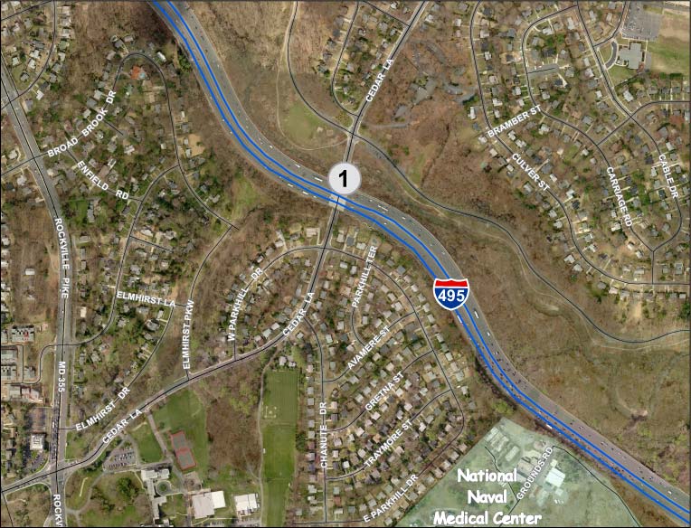
 The bridge site is in Rock Creek Park, immediately north of the Capital Beltway. Single-family R-60 residential neighborhoods, built in the 1940s and 1950s, are to the north and south. The Cedar Lane Unitarian Church is located at the northeast corner of the Cedar Lane/Beach Drive intersection.
The project would replace the bridge superstructure, retaining the existing substructure, resulting in no permanent change to the Rock Creek stream channel.
- The existing Cedar Lane roadway of four 10-foot-wide travel lanes would be changed to three 11-foot-wide lanes: one southbound lane and two northbound lanes (see Attachment 2).
- The sidewalk on the east side of the bridge would be replaced with a new five-foot-wide sidewalk.
- The sidewalk on the west side of the bridge would be replaced with a twelve-foot-wide shared use path.
- Lighting would be provided along Cedar Lane and under the Beltway.
Outside the bridge limits, a 10-foot-wide shared use path would be constructed, linking Rock Creek Trail on the north side of the Beltway to an existing six-foot-wide trail in Elmhirst Parkway Neighborhood Conservation Area Park.
Related projects
Several transportation projects have been proposed in response to the BRAC move of Walter Reed Army Medical Center to the National Naval Medical Center. The one closest to the subject project is the proposed improvements to the intersection of MD355 and Cedar Lane, whose eastern project limit is at Elmhirst Parkway, a little over 1,000 feet to the west.
Cedar Lane north of Beach Drive was reduced from four lanes to two lanes in 1999 in response to requests from residents for traffic-calming. MCDOT’s construction of intersection neckdowns to make this lane reduction permanent is currently scheduled for FY11.
Recommendations
- Widen the existing Elmhirst Parkway trail to eight feet minimum.
- Widen the proposed handicap ramp widths at the Beach Drive/Cedar Lane to match widths of the intersecting paths.
- Provide a southbound left turn lane on Cedar Lane to East Parkhill Drive.
- Construct the proposed sidewalk and path behind the handicap ramps.
- Provide landscaped offsets from the curb for both the sidewalk and shared use path where more space exists beyond the Capital Beltway bridge and provide street trees where possible.
- A park permit will be required for this project. All conditions of the permit must be adhered to.
Findings
Master Plan
Cedar Lane is classified as an Arterial road. Both the Bethesda-Chevy Chase Master Plan (south of the Beltway) and the Kensington-Wheaton Master Plan (north of the Beltway) recommend that Cedar Lane have a pavement width of 48 feet and a right-of-way width of 80 feet. The proposed project would reduce the existing pavement width from 40 feet to 34 feet, inconsistent with the greater width recommended in the Master Plan. It would be consistent however with the narrower section of Cedar Lane north of Beach Drive that is currently scheduled to be made permanent in FY11, as noted above in Related Projects.
The proposed shared-use path is consistent with the recommendations of the Countywide Bikeways Functional Master Plan.
Road Code and Associated Executive Regulations
The proposed typical section does not conform to an approved County Standard. The standards for a closed-section Suburban Arterial Road all have four lanes; no standard for a three-lane road exists. The lane widths are narrower than recommended and no buffer is provided for the sidewalk or shared use path.
AASHTO
The proposed sidewalk on the east side of the road does not meet the American Association of State Highway and Transportation Officials (AASHTO) recommendation to be two feet wider where immediately adjacent to the roadway curb to provide a greater measure of pedestrian safety and comfort. The proposed shared use path does meet this recommendation.
Analysis
Roadway
The Capital Beltway poses a major design constraint for this project because the bridge piers limit the width of Cedar Lane below the Beltway. The current roadway section has four 10-foot-wide travel lanes with five-foot-wide sidewalks on either side that abut the piers, between which there is stone riprap to the edge of the sidewalks. Constructing the proposed shared use path behind the piers would require that the path be elevated since the riprap is on a slope. This would in turn likely require that a separate bridge for the path be built over Rock Creek, with a greater stream impact (see Attachment 3).
To gain the space needed for the path, MCDOT proposes to reduce the number of southbound travel lanes from two to one. At the April, 14, 2010 public meeting sponsored by MCDOT, some residents expressed a concern that the narrower roadway would be unable to handle the traffic. MCDOT responded that the proposed single lane would be sufficient, continuing the operation of Cedar Lane north of Beach Drive, which has only a single southbound travel lane. The current Average Daily Traffic (ADT) is 12,565 vehicles per day; the forecast for 2030 is 15,485. Transportation Planning staff concurs that the single southbound travel lane will be able to accommodate the forecast traffic. The short southbound turn lane on the north leg of Cedar Lane at the Beach Drive intersection would remain.
Residents at the 4/14/10 meeting were also concerned that the plans did not include a southbound left turn lane to East Parkhill Drive and that backups would result from a single vehicle waiting to turn left. In a discussion with MCDOT and their consultants after the meeting, it was determined that a left turn lane could be provided. We recommend that this be done.
The proposed roadway section does not conform to the road standards recently approved as Executive Regulations as a follow-up to the Road Code update, as discussed above, but we believe that it is an appropriate response to competing demands from the various modes of traffic.
Where more space exists beyond the Capital Beltway bridge however, landscaped offsets from the curb should be provided for both the sidewalk and shared use path.
Maintenance of Traffic during Construction
Cedar Lane Bridge would be closed to vehicular traffic during construction, beginning the day after schools ends in June 2011 and re-opening the day before school begins in August 2011. The official detour route would be along Strathmore Avenue (MD547) and Rockville Pike (MD355).
Ride-On bus route 34 travels along Cedar Lane to MD355 past NIH/NNMC and terminates at the Bethesda Metro Station. This bus would be rerouted during construction down Beach Drive to MD185 and along Jones Bridge Road back to MD355. The Parks Department has agreed to allow these buses to travel along Beach Drive while the bridge is closed.
A temporary bridge would be provided for pedestrian and bicyclist traffic just to the west of the roadway bridge because of the long detours that would otherwise be required. The nearest crossing of Rock Creek to the west is at Grosvenor Lane, but there are no pedestrian facilities on Rockville Pike across the Beltway. The nearest crossing of Rock Creek to the east is at Connecticut Avenue. Both detour routes would be longer than two miles. (see Attachment 4)
A construction staging area is needed at the northeast corner of the bridge, and to eliminate potential conflicts with construction vehicles, a 330-foot-long segment of Rock Creek trail is proposed to be temporarily relocated from the south side of Beach Drive to the north side of the road. This would necessitate two additional road crossings of Beach Drive, one mid-block and one on the east leg of the Cedar Lane intersection. MCDOT and Parks staffs have agreed on a mutually acceptable location for the mid-block crossing. The trail detour would last about four months.
Residents at the 4/14/10 meeting expressed a concern about the safety of crossing Cedar Lane at the East and West Parkhill Drive intersection during the initial construction phase when the west side sidewalk is closed and the temporary bridge is under construction; Cedar Lane would still be open to traffic and would have to be crossed by residents of the west side of Cedar Lane who want to travel to Rock Creek Park, Kensington, or the detoured Ride-On route 34 that will be turning on Beach Drive. They have requested that a traffic signal be installed at the intersection during construction; MCDOT is currently conducting a traffic signal warrant study to respond to this concern.
Pedestrian Accommodation
Pedestrians would be accommodated in the permanent condition on the east side sidewalk and west side shared use path.
Handicap ramps at the East/West Parkhill Drive and Beach Drive intersections are designed with the proposed sidewalk and path at the curb line. This is inconsistent with ADA Best Practices since it unnecessarily requires users to change grade four times just to get around the corner. We recommend that the sidewalk and path be constructed behind the ramps to avoid this problem.
Bicyclist Accommodation
The Countywide Bikeways Functional Master Plan recommends a bike path along Cedar Lane from Beach Drive to MD355. MCDOT proposes to construct the path from Beach Drive to the northern end of the Elmhirst Parkway trail and we expect that most bicyclists will choose to use the park trail because it is flat and free of driveway crossings. By comparison, the existing sidewalk along Cedar has a dozen driveways and a 60-foot elevation difference.
The provision of a shared use path connection between Rock Creek Trail and the Elmhirst Parkway trail would greatly improve connectivity for our park system and between the Kensington and Bethesda areas. It would also provide a significant link in a network of bike paths that will serve NIH and NNMC.
One speaker at the 4/14/10 meeting asked MCDOT to widen the Elmhirst Parkway trail to improve bicyclist accommodation. MCDOT staff in turn asked us to construct the widening. Parks staff agrees that the widening is desirable but recommends that it be done by MCDOT as part of this project, although we can assist them in preparing the environmental documentation and addressing park permit issues.
The intersection of Cedar Lane and Beach Drive is also the intersection of the proposed shared use path and Rock Creek Trail. We recommend that the proposed ramp widths match path widths.
Landscaping
The proposed project does not propose any landscaping. As recommended above, we believe that landscaped buffers should be provided between the curb and sidewalk/shared use path where possible outside the bridge area. Trees should be provided in those buffers and additional trees may be required by Parks as part of the park permit.
Environmental Guidelines
The project area contains environmental buffer, 100-year floodplain and other sensitive features including forested areas. The property is within the Lower Rock Creek watershed, a Use I-P designation. The Countywide Stream Protection Strategy (CSPS) rates this watershed as fair to poor.
The project has no direct impacts on wetlands or forests. The only environmental buffer and floodplain impacts are the ones necessary and unavoidable to achieve the design standards of rehabilitating the bridge, and those impacts have been minimized to the greatest extent possible.
Forest Conservation
The project is exempt from submission of a forest conservation plan. A forest conservation exemption (#42010125E) was granted under the provisions of Section 22A-5(e) as “a state or county highway project”, but the applicant is required to minimize forest cutting, clearing and loss of specimen trees. The applicant has submitted a tree save plan (TSP) in conjunction with the Mandatory Referral process to show how the impacts have been minimized and what stress reduction methods are being used to further minimize impacts on trees.
Tree Save
Twenty-one significant and specimen trees are impacted by this project, 14 of which are specimen size. The TSP shows removal of two trees 24” DBH and greater, one is a 26” DBH Red Maple and the other is a 38” DBH Tuliptree. Both trees are within the Cedar Lane right-of-way (ROW) and are unavoidable, considering the design standards for the project. Overall the TSP shows a loss of nineteen (19) individual trees, seventeen (17) of which are less than 24” in DBH, and no loss of forest.
Park Impacts
Cedar Lane Bridge is located in Rock Creek Park, as is the Capital Beltway in this area. Because the bridge substructure will remain in place, the permanent impacts would be minimized. Temporary impacts of 1.69 acres are proposed on Park property.
Public Outreach
A public meeting for this project was held on April 14, 2010 and was attended by about 30 citizens.
Status
- The Planning Board approved the staff recommendations with comments on June 10, 2010 and transmitted comments to the Montgomery County Department of Transportation.
View appendices detailing applicable master plans, policies, guidelines and other resources.