Connecticut Ave (MD 185) / Jones Bridge Road / Kensington Parkway
Description
 Click for a larger view
Mandatory Referral No. MR2010808
Phases 1 and 2 of this intersection project, extending along Connecticut Avenue (MD185) from just north of Manor Road to just south of the Capital Beltway (I-495), are under construction. Read the staff reports:
Phase 3 was approved in July 2012. Read the staff report.
Background
The intersection projects will:
- Construct a continuous southbound right turn lane on MD185 from the ramp from the Inner Loop to Jones Bridge Road
- Remove the free-right-turn island in the northwest corner of the MD185/Jones Bridge Road intersection
- Construct an additional northbound through lane on MD185 from 300 feet north of Manor Road to the Capital Beltway
- Construct a new sidewalk along the east side of MD185 from Montrose Driveway to Inverness Drive at the northbound ramp to the Inner Loop
- Reconstruct the majority of the sidewalks within the limits of work to be offset from the curb
- Make the intersections within the limits of work ADA-compliant
- Construct a stormwater management facility at the end of the Inner Loop ramp to southbound MD185.
- Construct an additional left turn lane on eastbound Jones Bridge Road, requiring the relocation of the HHMI boundary wall west of the intersection.
- Remove the free-right-turn island in the southwest corner of the MD185/Jones Bridge Road intersection
- Replace the westbound through-right lane with separate through and right lanes, requiring the relocation of the boundary wall of the Chevy Chase Park community along Jones Bridge Road east of the intersection.
- Construct an eight-foot-wide shared use path on the south side of Jones Bridge Road between Platt Ridge Drive and MD185 and construct five-foot-wide sidewalks in the other three quadrants of the intersection.
View appendices detailing applicable master plans, policies, guidelines and other resources.
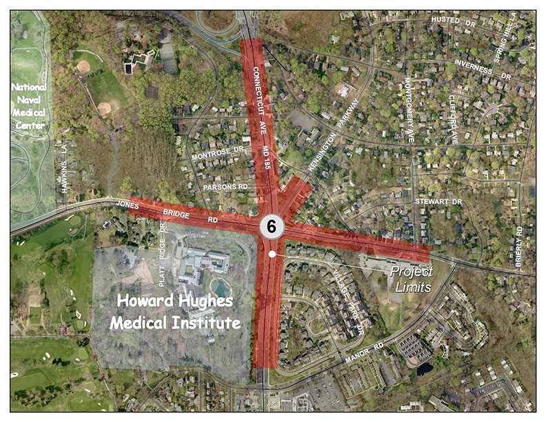
Existing Configuration
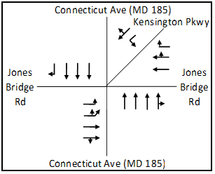
Lane Configuration after completion
of phases 1 & 2
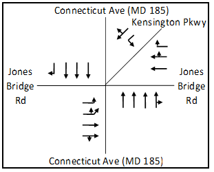
Lane Configuration after completion
of phase 3
Phases 1 and 2
- July 22, 2010: The Planning Board disapproved the project and transmitted comments (80 KB) to the State Highway Administration.
- October 22, 2010: SHA responded with comments (pdf, 200KB).
Phase 3
- July 20, 2012: The Planning Board transmitted comments (pdf, 3.6MB) to the State Highway Administration.
- August 21, 2012: SHA responded with comments(401 KB).
Date of last update: October 5, 2012