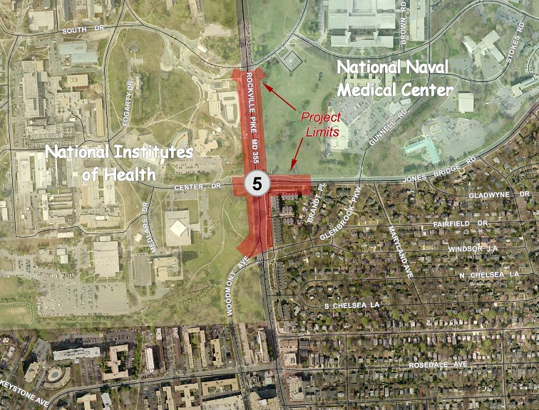
Rockville Pike (MD 355) / Center Drive/Jones Bridge Road
Description
 Click for a larger view
Mandatory Referral No. MR2010806
The project limits extend from Woodmont Avenue to South Drive/South Wood Road along MD355, and about 250 feet along Jones Bridge Road. The project would:
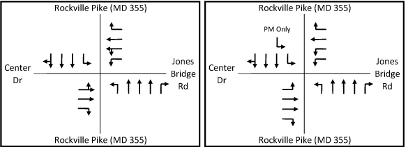
- Implement Dynamic Lane Controls to convert the leftmost southbound through lane on MD355 to a left-turn lane during the PM peak
- Remove the split-phase traffic signal operation at MD355/Center Drive /Jones Bridge Road
- Construct a right turn lane on eastbound Center Drive
- Modify the curb radii at the Rockville Pike (MD355)/Jones Bridge Road/Center Drive intersection
- Enlarge the curb radius in the northwest corner of the Rockville Pike (MD355)/South Drive intersection
- Narrow the entrance to southbound Woodmont Avenue to shorten the pedestrian crossing distance
- Reconstruct the sidewalk on the south side of Jones Bridge Road to be offset from the curb
- Reconstruct and widen the shared use path on the west side of MD355
- Make the intersections within the limits of work ADA-compliant
- Slightly lengthen the southbound left turn lane on MD355 at Jones Bridge Road
Existing Configuration Proposed Configuration
View the engineering drawings for this project.
Recommendations
General
- Make additional area bicycle and pedestrian improvements needed to provide safe and convenient access to the NIH and NNMC campuses within the overall BRAC traffic impact area rather than the limits of the individual intersection projects within that area.
- Revise the proposed handicap ramp designs to meet ADA Best Practices wherever possible, including locating sidewalks and paths behind handicap ramps at intersections to avoid unnecessary grade changes for handicapped persons.
- Widen proposed sidewalks and shared use paths by two feet where they are located adjacent to the curb.
- At intersections where SHA believes that a safe ADA-accessible crossing cannot be provided, we recommend that the intersections be signed to prohibit the crossing and to direct pedestrians to the safest crossing.
- Provide supporting documentation of any final decision not to provide crosswalks on all legs of signalized intersections.
- Evaluate the lighting along the roads covered by these projects for their adherence to current AASHTO lighting standards and upgrade and augment these facilities where needed.
- Continue to coordinate with MCDOT on their Countywide Bus Rapid Transit Study and consider the designation of additional through travel lanes as "diamond lanes" for restricted use by buses and high-occupancy vehicles during peak periods along the State highways covered by these projects.
- Consider providing a four-foot-wide smooth concrete panel as part of the proposed decorative crosswalks to accommodate persons with disabilities.
- Where large volumes of pedestrians and bikes are expected, consider making the crosswalks wider than ten feet.
- Provide shade trees between the curb and sidewalk wherever possible. Major deciduous trees are recommended over flowering trees in the ROW to provide a better sense of scale on these wide roads. Utilize species of trees that can accommodate the pruning needed to accommodate overhead utilities.
- Impervious surfaces in the median should be avoided wherever possible in favor of landscaping. Four-foot-wide medians should be planted with liriope.
- Landscaping and streetscaping should be provided that ensures community compatibility; reflects the national importance of the National Institutes of Health, the National Naval Medical Center, and the Howard Hughes Medical Institute; and is compatible with the landscaping plans of those institutions.
- Work with our staff to achieve mutually acceptable revisions to landscaping plans for all four intersections within 60 days or prior to submission of Phase 3 for the MD185/Jones Bridge Road project.
- Provide responses to all other comments within 60 days.
Specific to Rockville Pike (MD355)/ Center Drive/Jones Bridge Road Intersection
- Provide a crosswalk on the north leg of MD355 at Jones Bridge Road.
- Offset the proposed shared use path in the northwest quadrant of the MD355/Center Drive intersection so that it is outside the handicap ramp area.
- Provide shade trees between the shared use path/sidewalk and curb along both sides of MD355.
- Continue to coordinate with MCDOT on the MD355 Crossing Study and any resulting project. If large-scale utility relocation is required for a subsequent project, particularly if the NNMC fence is to be moved, we recommend that the undergrounding of utilities be considered. If the utilities are not undergrounded, the poles should be moved back to provide an eight-foot-wide landscape buffer between the curb and sidewalk.
- Offset the sidewalk on the traffic island at Glenbrook Parkway at MD355 as well as the ramps on either side of the island by about 12-15 feet from the curb to improve pedestrian safety.
Findings
Master Plan
Rockville Pike (MD355): The project is consistent with the Master Plan in regard to the number of lanes and the provision of a shared-use path on the west side of the roadway but inconsistent with the provision of landscaping.
Jones Bridge Road: The project is consistent with the Master Plan.
Woodmont Avene: The proposed roadway is consistent with the Master Plan.
SHA’s Bicycle and Pedestrian Design Guidelines (MD355 only)
Intersection: No crosswalk would be provided on the north leg of the MD355/Jones Bridge Road intersection.
Sidewalk: Continuous sidewalks or shared use paths would be provided within the project limits.
On-road bike accommodation: The recommended bike lanes would not be provided, but the curb lanes would be slightly wider.
Landscape buffers: Landscape buffers would be provided for the proposed shared use paths and sidewalks, with the exception of the MD355 path south of Jones Bridge Road to avoid impacting large trees on the NIH campus, and the path on Jones Bridge Road to avoid impacting the NNMC fence and wall close to the intersection.
American Association of State Highway and Transportation Officials (AASHTO)
About 250 feet of the proposed shared use path on Jones Bridge Road and about 300 feet of the proposed shared use path on MD355 would not meet the AASHTO recommendation to be two feet wider where immediately adjacent to the roadway curb because of the fence and wall, as well as the tree impacts noted above.
American with Disabilities Act (ADA)
The project meets the minimum accommodation required by ADA, but does not meet ADA Best Practices in that sidewalks and paths are located too close to the curb at intersection corners, requiring users to negotiate multiple ramps to travel along the sidewalk around the corner.
Analysis
Roadway
The impacts of the proposed improvements on traffic operations are summarized below:
Location |
Without Improvements |
With Improvements |
||||
CLV |
Delay per vehicle AM/(PM) in seconds |
Weekday Peak Hour Delay (hours) |
CLV |
Delay per vehicle AM/(PM) in seconds |
Weekday Peak Hour Delay (hours) |
|
355/Jones Bridge |
1377 / (1769) |
57 / (105) |
266 |
1366 / (1414) |
41 / (49) |
146 |
SHA proposes to make only fairly minor physical improvements to this intersection because they intend to implement Dynamic Lane Controls to convert the leftmost southbound through lane on MD355 to a left-turn lane during the PM peak. Two left turn lanes would be used to minimize the time that northbound MD355 traffic has to stop at the signal to wait for southbound left turns to pass through the intersection. This operation would be similar to that of Spring Street at Colesville Road (US29), where the normal operation has a double left and a through-right lane, but the through-right becomes a left-through-right in the PM peak, constituting a partial third left turn lane.
Pedestrian Accommodation
Pedestrians would be accommodated on the sidewalk and shared use path on both MD355 and Jones Bridge Road.
Where sidewalks and shared use paths are immediately adjacent to the roadway curb, AASHTO recommends that they be two feet wider to provide a greater measure of pedestrian safety and comfort. However, the shared use paths on both MD355 and Jones Bridge Road have constraints that make it very difficult to widen them – the large trees on the NIH campus and the NNMC fence - so we will forego a recommendation to widen them.
There is a large landscaped traffic island to separate entering and exiting traffic on Glenbrook Parkway at MD355. Currently, pedestrians must walk at the same level of the roadway adjacent to traffic, a potentially hazardous location. SHA has proposed to construct a curb and raise the level of the walkway, greatly improving pedestrian safety, but not taking advantage of the space available. We recommend that this sidewalk and the ramps on either side of the island be constructed to be offset from the curb by about 12-15 feet.
Off-Road Bicyclist Accommodation
Bicyclists would be accommodated via the shared use paths on both roads.
MCDOT proposes to construct a shared use path along the north side of Jones Bridge Road, a project that is scheduled to be reviewed by the Board on 7/15/10. This is reflected in SHA’s plans. However, no crosswalk is currently proposed on the north leg of MD355, making the route very circuitous to get from the Jones Bridge path to the MD355 path headed north to the Metro or to other destinations. It would also be cumbersome to get from the same point into the NIH campus. The existing traffic island between the westbound right turns and the other Jones Bridge Road traffic carries a utility pole that SHA has said it would be very expensive to move. Retaining this unusual island makes it more complicated than most intersections to accomplish a north leg crosswalk, but this would be made easier if the curb radii were reduced.
We recommend that this north-leg crosswalk be included in this project.
Landscaping
The Master Plan recommends trees on both sides of Rockville Pike between the curb and sidewalk/path and in the median, but the proposed project has none. Very few shade trees are proposed and all are behind the proposed shared use path along NIH’s frontage. All other landscaping is behind the sidewalk/path.
There is a substandard buffer width adjacent to the sidewalk just north of the Jones Bridge Road intersection, but the landscape buffer is generally at least five feet, not ideal, but sufficient room to plant shade trees between the curb and sidewalk or path. We recommend that this tree planting be done.
Overhead Utilities
The Master Plan recommends relocating utility poles to provide more space for sidewalks and trees on the roadside. The space between the curb and NNMC security fence on the east side of MD355 is very constrained. There are no plans at present to relocate the fence, however it would be impacted by one or more alternatives under consideration as part of the MD355 Crossing Study now being undertaken by MCDOT.
The Planning Board is scheduled to receive a briefing on this study on 7/29/10. MCDOT anticipates selecting an alternative by the end of September 2010, and it is very possible that a project could be funded for construction in the near term. We recommend that SHA continue to coordinate with MCDOT on this project. If large-scale utility relocation is required for the MD355 Crossing project, particularly if the NNMC fence is to be moved, we recommend that the undergrounding of utilities be considered. If the utilities are not undergrounded, the poles should be moved back to provide an eight-foot-wide landscape buffer between the curb and sidewalk.
Environmental Guidelines
The project is within the Lower Rock Creek watershed, a USE I-P designation. The Countywide Stream Protection Strategy (CSPS) rates this watershed as poor.
The project has no direct impacts on streams, wetlands, or environmental buffers.
Forest Conservation
The project is exempt from submission of a forest conservation plan. The project is also exempt from submitting a forest conservation exemption (#42010206E) under Section 22A-5(f) of the County code. This section provides exemptions from submitting forest conservation plans as “a governmental project reviewed for forest conservation purposes by the State Department of Natural Resources under the Code of Maryland Regulations”. The exemption was confirmed on May 20, 2010.
Historic
There are two Master Plan historic properties within the project limits, the G.F. Peter Estate on the NIH campus immediately south of South Drive, and the Bethesda Naval Hospital Tower site, which extends from just north of North Wood Road to Jones Bridge Road and along Jones Bridge. The historic buildings on these sites are set far back from the road and would be unaffected. The impacts on their historic settings will be determined by the Maryland Historical Trust but no adverse finding is anticipated.
Park Impacts
This project has no impact on park property.
Status
- The Planning Board approved the staff recommendations with comments on July 22, 2010 (pdf, 207KB) and transmitted comments to the State Highway Administration.
- SHA responded with comments on October 22, 2010 (pdf, 535KB).
View appendices detailing applicable master plans, policies, guidelines and other resources.
Date of last update: Noember 16, 2010