Planning areas
Montgomery County, MD
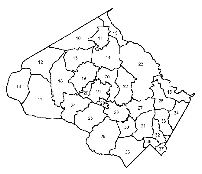
| Legend | Planning areas |
| 10 | Bennett & Little Bennett Watershed |
|---|---|
| 11 | Damascus & Vicinity |
| 12 | Little Monocacy Basin Dickerson - Barnsville |
| 13 | Clarksburg & Vicinity |
| 14 | Goshen, Woodfield Cedar Grove & Vicinity |
| 15 | Patuxent Watershed Conservation Area |
| 16 | Martinsburg & Vicinity |
| 17 | Poolesville & Vicinity |
| 18 | Lower Seneca Basin Parts One, Two, Three |
| 19 | Germantown & Vicinity |
| 20 | Gaithersburg & Vicinity |
| 22 | Upper Rock Creek Watershed |
| 23 | Olney & Vicinity |
| 24 | Darnestown & Vicinity |
| 25 | Travilah & Vicinity |
| 26 | Rockville |
| 27 | Aspen Hill & Vicinity |
| 28 | Cloverly - Norwood |
| 29 | Potomac - Cabin John & Vicinity |
| 30 | North Bethesda - Garrett Park |
| 31 | Kensington - Wheaton |
| 32 | Kemp Mill, Four Corners & Vicinity |
| 33 | Colesville, White Oak & Vicinity |
| 34 | Fairland - Beltsville & Vicinity |
| 35 | Bethesda - Chevy Chase & Vicinity |
| 36 | Silver Spring & Vicinity |
| 37 | Takoma Park |
| Source: Montgomery County Department of Park and Planning, Research and Technology Center | |
Geographies
Most data are reported for three geographies:
- Jurisdictions in the Montgomery County Region, an area defined by the M-NCPPC Research and Technology Center which includes localities neighboring Montgomery County. The Montgomery County Region is a subset of the localities in the Baltimore-Washington Consolidated Metropolitan Statistical Area as defined by the US Census Bureau.
- Montgomery County Planning Areas are subareas of the County whose boundaries were defined decades ago for the purposes of reporting demographic and other data. Because the boundaries of these areas have not changed over time, it is possible to report time series data for these areas. These planning areas should not be confused with Master or Sector Plan boundaries, which may be different.
- Montgomery County Policy Areas are subareas of the County defined for the purposes of implementing the County Adequate Public Facilities Ordinance through the Annual Growth Policy (AGP) transportation test. Policy Area boundaries have changed fairly frequently since the first AGP was adopted in 1986 and often time series data are not available at this geography.