Chrome
In the menu to the right of the address bar, select and set Zoom level. Menu > Zoom > +
Firefox
In the View menu, select Zoom. View > Zoom > Zoom In
Internet Explorer
In the View menu, select Text Size. View > Text Size > Largest
Safari
In the View menu, select Zoom In. View > Zoom In Macintosh Shortcut: Command+
| >Back to: > Our website - home > Research - home | ||||||||||||||||||||||||||||||||||||||||||||||||||||||||||||||||||||||||||||||
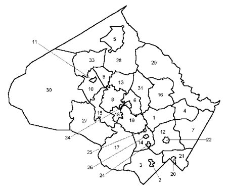
Notes: Derwood and Shady Grove are separate policy areas but demographic data are available only for the two areas combined. This is also true for Friendship Heights (included in the Bethesda/Chevy Chase data, and for Glenmont, included in the Kensington/Wheaton data. There are no policy areas labelled "23" or "32" on this map. Geographies: Most data are reported for three geographies: (1) jurisdictions in the Montgomery County Region, an area defined by the M-NCPPC Research and Technology Center which includes localities neighboring Montgomery County. The Montgomery County Region is a subset of the localities in the Baltimore-Washington Consolidated Metropolitan Statistical Area as defined by the US Census Bureau. (2) Montgomery County Planning Areas are subareas of the County whose boundaries were defined decades ago for the purposes of reporting demographic and other data. Because the boundaries of these areas have not changed over time, it is possible to report time series data for these areas. These planning areas should not be confused with Master or Sector Plan boundaries, which may be different. (3) Montgomery County Policy Areas are subareas of the County defined for the purposes of implementing the County Adequate Public Facilities Ordinance through the Annual Growth Policy (AGP) transportation test. Policy Area boundaries have changed fairly frequently since the first AGP was adopted in 1986 and often time series data are not available at this geography.
Click Here to Return to the Population Statistics Menu
>Back
to: > Our
website - home > Research
- home [an error occurred while processing this directive]
|
|
|