Corridor Cities Transitway
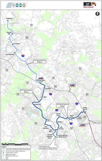 Corridor Cities Transitway Study Area
Governor Martin O’Malley announced on May 11, 2012 that the long planned Corridor Cities Transitway (CCT) would be Bus Rapid Transit (BRT). The BRT system would offer attractive and frequent high-capacity service between the Shady Grove Metrorail Station and the COMSAT site in Clarksburg, a distance of about 15 miles.
When completed, the CCT would consist of 16 stations serving major activity centers such as King Farm (two stations), Crown Farm, DANAC, the Life Sciences area (three stations), Kentlands, NIST, First Field, Metropolitan Grove MARC, Germantown Town Center, Cloverleaf, and Dorsey Mill in addition to Shady Grove and COMSAT (see map below).
Ridership forecasts for 2035 exceed 47,000 for a typical weekday. The project will be constructed in two phases, with the first phase being the segment from Shady Grove to Metropolitan Grove. The total estimated capital cost is $828 million, with $545 million of that total related to the Phase I construction.
Background
The CCT is an important part of the planned transportation infrastructure for Montgomery County and is a central element of the following plans:
- Shady Grove Sector Plan (2006)
- Great Seneca Science Corridor Master Plan (2010)
- Germantown Master Plan
- Germantown Employment Area Sector Plan (2009)
- Clarksburg Master Plan (1994)
- 10 Mile Creek Area Limited Amendment (2014)
- Countywide Transit Corridors Functional Master Plan (2013)
In addition, the CCT is a key component of the infrastructure of the City of Gaithersburg in support of existing and future development at Crown Farm and the Kentlands.
Project schedule
Key future milestones, according to the latest project schedule, include the following:
- Fall 2014 – Complete preliminary engineering and final environmental document
- Winter 2014 / 2015 – Approval to begin next phase of engineering
- Summer 2017 – Finalize funding agreements
- Fall 2018 - Begin construction
- 2020 – Begin service
M-NCPPC staff contact
David Anspacher, Planner Coordinator
301-495-2191
david.anspacher@montgomeryplanning.org
Date of last update: December 3, 2012