Shady Grove Sector Plan
Approved and Adopted 2006
The Shady Grove Sector Plan envisions the transformation of the area surrounding the Shady Grove Metro Station into a lively mixed-use community. On January 17, 2006, Montgomery County Council approved the Shady Grove Sector Plan. On March 15, 2006, the Sector Plan was formally adopted by M-NCPPC. Download the Approved and Adopted Plan (pdf, 19.6 MB)
The plan is the result of four years of community meetings, charrettes and worksessions with the Planning Board and County Council to determine the future development of the area surrounding the Shady Grove Metro Station and establishes the framework to transform the area into a place that accommodates living, working and playing opportunities.
In 2006, the Shady Grove Sector Plan received the Outstanding Plan Award for Jurisdictions over 100,000 from the Maryland Chapter of the American Planning Association.
News and Events
- New! View the Biennial Master Plan Monitoring Report (July 2015)
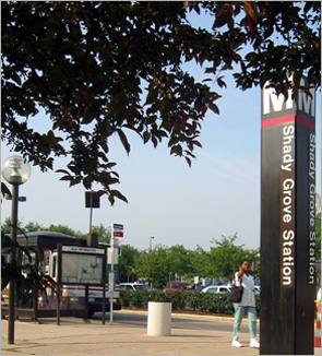 The plan proposes mixed use housing at the Shady Grove metro station area.
A Transformation of Place
The Shady Grove Sector Plan aims to:
- Feature a mix of residential, office, retail and commercial development concentrated at the Metro station with parks, recreation and other community serving uses.
- Strengthen the Derwood community by providing compatible development, better access to the Metro station, increased recreation and park opportunities and new public facilities including a library and an elementary school.
- Support technology uses along the Shady Grove Technology Corridor.
- Achieve between 5,400 and 6, 340 new residential units and approximately 7,000 new jobs within the planning area.
- Provide a variety of housing choices with affordable and workforce housing.
- Create a new street network in the Metro Neighborhoods that improves access to the Metro Station and expand bikeways and the trail system serving the community.
- Emphasize transit use by requiring new development to mitigate vehicular trips.
- Create a series of open spaces, urban and public parks, and streetscapes with ground level retail/commercial uses that accommodate pedestrians and encourage street life.
- Stage new development to ensure timely provision of public facilities such as schools, parks and transportation improvements.
Shady Grove Station (Montgomery County Service Park redevelopment)
Montgomery County officials in the County Executive's Office are leveraging public land at the Montgomery County Service Park, located in the sector plan area along Crabbs Branch Way, while investing in new public facilities and creating an urban village. The County purchased several properties to facilitate the service park redevelopment as envisioned in the sector plan, including Casey 6 and 7, the Webb Tract on Snouffer School Road, and the GE Tech/National Geographic site on Darnestown Road (Route 28).
The County signed an agreement with EYA of Bethesda to begin redeveloping a portion of CSP into residential and non-residential development, beginning with the west side of Crabbs Branch Way.
- January 23, 2014: The Planning Board approved Shady Grove Station-Westside for 1,521 residential dwelling units, including 211 Moderately Priced Dwelling Units and 116 Workforce Housing units; 41,828 square feet of retail and space for a public library. The Board also approved Shady Grove Station Public Infrastructure for Shady Grove Station. The proposed project will: reconstruct Crabbs Branch Way between Shady Grove Road to the Metro Access Road into an urban boulevard with on-street parking, new streetscape and shared use paths; install a new sidewalk along the Shady Grove Road and new crosswalks at the intersection of Crabbs Branch Way and Shady Grove Road; construct a new hiker/biker trail at the stormwater management parcel at Crabbs Branch Way and Redland Road; construct a new sidewalk with streetscape and roadway modifications at the Shady Grove Metro Station exit road; and upsize the existing sanitary sewer to serve the Shady Grove Station development.
- February 13, 2013: EYA presented the site plan (5.6 MB) for the Shady Grove Station west side at a public meeting. The west side of Shady Grove Station will build 1,114 multi-family dwelling units, 407 residential townhouses, and a public library.
- September 6, 2012: The Planning Board will consider a preliminary plan application for Shady Grove Station (County Service Park redevelopment) preliminary plan.
- September 19, 2011: Montgomery County and EYA presented the preliminary plan (pdf, 12MB) for the Service Park redevelopment at the Parks Department Training center on Crabbs Branch Way.
Monitoring Report
Although not required by the Shady Grove Sector Plan, the Biennial Master Plan Monitoring Report provides the status of new development, public facilities, and staging. There are significant public investments associated with the County Executive’s “Smart Growth Initiative” and moving the recommended development into the next stage. The Shady Grove section of the monitoring report is from pages 61 to 71. Read report
Montgomery County Smart Growth Initiative
The County Executive created the Smart Growth Initiative in 2008.
Development Activity
Several private and public sector projects have been approved since the Sector Plan was adopted, including Derwood Bible, Somerville Property, and Casey 6 and 7.
Learn more about each plan:
- Townes at Shady Grove -(F.K.A. Somerville)
- David F. Bone Equipment Maintenance and Transit Operations Center (EMTOC)- (F.K.A. EMOC at Casey 6 and 7)
Staging
All of the Stage 1 triggers have been implemented. The table below provides an update of the approved development and its relationship to Stage 1:
| Sector Plan | Residential Development | Non-Residential Jobs |
|---|---|---|
| Stage 1 limits with County Service Park Redevelopment | 2,540 dwelling units | 1,570 jobs |
Allocated Development |
||
| 120120080: Shady Grove Station Preliminary Plan | 2,210 dwelling units | 630 jobs 41,828 sf (retail; 400 sf per job): 104 jobs 131,422 sf (office; 250 sf per job): 526 jobs |
| 120090100: P146 Shady Grove Metro (Somerville property) Preliminary Plan | 156 dwelling units | N/A |
Total Approved Development (Summer 2014) |
2,366 dwelling units |
630 jobs |
Remaining Stage 1 Development |
174 dwelling units |
940 jobs |
The following items are Stage 2 triggers:
- Evaluate the need and schedule of the new elementary school and ask MCPS to begin planning and program accordingly.
- Fund acquisition or dedication for a local park with at least one adult-sized ball field. If County Service Park relocates, dedication of required park facilities should be required as part of the preliminary plan approval of private development. Fund construction for one park.
- The Planning Board will consider the aggregate performance of all TMAgs in the Shady Grove Policy Area in the decision to move to Stage 2. If sum total of vehicle trips from all participating sites exceeds the sum of the allowed trip caps, then the plan should not be considered ready to move to the subsequent stage.
- Each of the major intersections in the Sector Plan area must operate at or better than its respective Growth Policy Local Area Transportation Review (LATR) level of service standard or congestion level at the time of the Plan’s adoption, whichever is greater. Traffic will be measured from existing and approved development on a network programmed for completion four years later.
- Fund the Metro Access Partial Interchange for completion within the first four years of the Capital Improvements Program to ensure adequate access to the Metro station.
- Fund the MD 355/Gude Drive interchange for completion within the first four years of the Consolidated Transportation Program, the Capital Improvements Program, or other transit or transportation improvements that would make the intersection function at an acceptable level. ‘Acceptable’ is defined as the applicable intersection congestion standard in the Growth Policy.
- Planning Board must make determination that Stage 2 can proceed.
Montgomery County Capital Improvements Program
The County’s CIP lists long-range development plans for capital projects from different County agencies. The County Executive must submit a CIP to the Council every other year, under Section 302 of the County’s Charter.
- Redland Road from Crabbs Branch Way to Baederwood Lane
This project includes widening a portion of Redland Road along with storm drain modifications and a new 8’ shared use path that improves pedestrian and bike access in the area. - MCPS Bus Depot and Maintenance Relocation This is a comprehensive feasibility study to relocate MCPS school buses.
Shady Grove Sector Plan Implementation Advisory Committee
Members
Name |
Affiliation |
|---|---|
| Kellie Brindley | Mill Creek |
| John Compton | Town of Washington Grove |
| Pat Labuda | Shady Grove Civic Alliance |
| Pam Lindstrom (chair) | Gaithersburg resident |
| Michael McInerney | Sommerville Properties |
| Connie McKenna | Redland Station |
| Joe Parello | Old Derwood |
| Brian Pierce | King Farm |
| Jeff Reznick | Park Overlook |
In 2006, the Planning Board established the Shady Grove Implementation Advisory Committee. The Committee is responsible for advising the Planning Board on development activities in the Sector Plan area. Residents and property owners comprise the advisory committee.
The Committee meets on a quarterly basis and when it is necessary to address implementation issues. Pam Lindstrom is the current committee chair.
Meetings are held at the Montgomery County Parks Department Training Center, 16668 Crabbs Branch Way.
Meeting schedule
- June 15, 2016 (agenda)
- March 2, 2016 (agenda; summary notes)
- April 16, 2015 (agenda; summary notes)
Staff contact
N’kosi Yearwood
301-495-1332 | nkosi.yearwood@montgomeryplanning.org
Last updated: August 16, 2016