Germantown Master Plan
Approved and Adopted July 1989
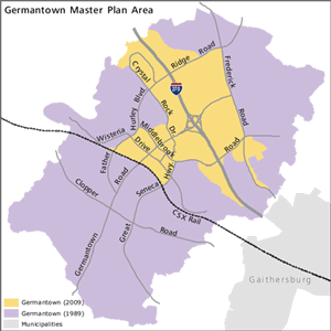 Click the orange section to learn more about the Germantown 2009 Employment Area.
Two plans guide the future of Germantown — this master plan and the 2009 Germantown Employment Area Sector Plan (see map). Please refer to the Sector Plan for the approximately 2,400-acre area around I-270 and the future Corridor Cities Transit Stations, and to this master plan for the balance of Germantown.
Details
Plan Highlights
Planning Framework
Townscape Design
Places
Linkages
Signage
Land Use and Zoning
Objectives
Germantown - A New Community
Land Use and Zoning Recommendations
Environmental Concerns
Environmentally Sensitive Areas
Water Supply and Sewerage Policies
Noise Concerns
Natural Features
Transportation
Character of Roadways
Transportation Analysis
Recommendations of the Master Plan
Community Facilities
Public Schools
Public Parks and Recreation
Other Community Facilities
Human Services and Land Use Issues
Demographic Characteristics
Child Day-care
Elderly
Housing for Special Populations
Historic Resources
Implementation
Germantown's Historic Resources
20th Century Historic Sites
Implementation
Master Plan
Sectional Map Amendment
Zoning Text Amendments
Capital Improvements Program
Water Supply and Sewerage System Plan
Subdivision Regulations
Annual Growth Policy
Transfer of Development Rights
Incentives for Historic Preservation
Fiscal Considerations
The Capital Improvements Program
Current Fiscal Situation
Possible Future Fiscal Impacts
- Glossary of Terms
- Summary of Zoning Classifications
- Tables
- County Council Resolution of Approval (11-1498)
- M-NCPPC Resolution of Adoption (89-11)
- County Council Resolution of Approval (11-2283)
- M-NCPPC Resolution of Adoption (No. 90-43)
- Master Plan Amendments: 1974-1986
- Retail Trends and Implications for Germantown
- Explanation of Water Class Uses
- Performance Criteria for Development in Analysis Areas K1-2 and NE-1
- Summary of Environmental Regulations and Guidelines for Development Proposals
- Using Transportation Models for the Analysis of the Germantown Master Plan
- Initial Modeling Efforts
- Future Travel Characteristics in Germantown
- Roadway Descriptions and Changes of Alignment
- School Needs in Germantown
- Park Facilities
- Historic Resources
- Capital Projects
- Executive Summary of "Market Analysis - Gemantown Town Center"
- Roadside Character
List of Tables
- Mix of Housing Types in Germantown
- End-State Relationship of Employment Opportunities to Employed Residents
- Town Center: Land Use and Zoning Recommendations
- Employment Corridor: Land Use and Zoning Recommendations
- Churchill Village: Residential Development
- Churchill Village: Land Use and Zoning Recommendations
- Gunners Lake Village: Residential Development
- Gunners Lake Village: Land Use and Zoning Recommendations
- Clopper Village: Residential Development
- Clopper Village: Land Use and Zoning Recommendations
- Kingsview Village: Residential Development
- Kingsview Village: Land Use and Zoning Recommendations
- Middlebrook Village: Residentail Development
- Middlebrook Village: Land Use and Zoning Recommendations
- Neelsville Village: Residential Development
- Neelsville Village: Land Use and Zoning Recommendations
- Roadway Classifications
- Correspondence Between Transit Availability and Average Level of Service Standards
- Summary of Roadway Assumptions for Recommended Land Use/Transportation Scenarios
- End-State Building Area Limitations
- Public Schools by High School Clusters
- Aging of Germantown's Populations
- Germantown's Historic Resources
- Acres by Zone: Comparison of 1974 Master Plan and This Amendment
- Analysis Areas Recommended for Rezoning by Sectional Map Amendment
3-1 Theoretical Maximum Dwelling Units/Population
in Germantown
3-2 Comparison of 1974 Master Plan and Comprehensive
Amendment: Acreage
3-3 Proposed Land Uses by Village: Acreage
3-4 Comparison of 1974 Master Plan and Comprehensive
Amendment: Residential Land Use
3-5 Population, Local Parkland, and Public Schools
by Village
G-1 Summary of Selected Results of Areawide Transportation
Analysis
H-1 A Summary of the Trip Distribution Results
for Final Draft Alternative
J-1 Summary of Public School Needs
J-2 School Child Yields from Movers
J-3 School Child Yields from Movers and
Non-Movers
J-4 Demographic Model: Projections of Dwelling
Units and School-Aged Children
J-5 Capacities of Existing and Programmed
Schools
J-6 Relative Build-Out of Dwelling Units
and Elementary School Capacity
N-1 Germantown Town Center Concept Land Use Mix
List of Figures
- Location Map
- Planning Area Map
- Community Concept Plan
- Town Center: Concept Diagram
- Employment Corridor: Concept Diagram
- Churchill Village: Concept Diagram
- Gunners Lake Village: Concept Diagram
- Clopper Village: Concept Diagram
- Kingsview Village: Concept Diagram
- Middlebrook Village: Concept Diagram
- Neelsville Village: Concept Diagram
- Roadway System
- Signage
- Work Locations of Germantown's Employed Residents
- Analysis Areas
- Town Center: Analysis Area
- Employment Corridor: Analysis Area
- Churchill Village: Analysis Area
- Gunner Lake Village: Analysis Area
- Clopper Village: Analysis Area
- Kingsview Village: Analysis Area
- Middlebrook Village: Analysis Area
- Neelsville Village: Analysis Area
- Environmentally Sensitive Areas and Wooded Areas
- Existing and Proposed Conservation Easements, Areas, and Nontidal Wetlands
- Existing, Proposed and Potential Regional Stormwater Management (SWM) Facilities
- Watershed Areas, Floodplains and Danger Reach
- Existing and Proposed Major Sewer and Water Facilities
- Relative Roadway Noise Contours
- Roadway Cross Sections
- Intersection Rights-of-Way
- Intersection Level of Service
- Employment Corridor: Anticipated Development
- Existing and Proposed Roadway Systems
- Proposed Realignment of Midcounty Highway (M-83)
- Amendments to the Clarksburg Master Plan
- Existing and Proposed Transit Facilities
- Proposed Corridor Cities Transit Easement
- Existing and Proposed Bikeways, Major Pedestrian Connections, and Equestrian Trails
- Existing and Proposed Community Facilities
- Existing and Proposed Public Parks
- Historic Resources
- Areas Recommended for Rezoning by Sectional Map Amendment
- Existing Water Service Categories
- Existing Sewer Service Categories
- Transferable Development Rights Process
- B-1: 1974 Master Plan - Village Center Locations
- B-2: 1989 Master Plan - Village Center Locations
- F-1: Analysis Context in Using Transportation Model
- F-2: Schematic Structure of Transportation Model
- F-3: Policy Areas and Traffic Zones
- F-4: Traffic Analysis Subzones
- F-5: Roadway Systems
- F-6: Schematic Illustration of a Four Step Transportation Model
- F-7: Relation of the EMME/2 Model to the Analysis Context
- G-1: Anticipated AM Peak Hour Patterns of Movement
- H-1: Trip Generation Results
- H-2: Projected Trip Distribution Patterns
- H-3: Screenline Volumes
- K-1: Existing and Proposed Public Parks
- L-1: Environmental Setting or Neelsville Presbyterian Church (Site #19/5)
- L-2: Environmental Setting for Waring Crawford Farm (Site #19/11)
- L-3: Germantown Historic District and Adjacent Historic Resources
- M-1: Capital Projects
- O-1: Setbacks from I-270
- O-2: Residential Setbacks from Roadways
NOTE: Please be aware that the page numbering shown on each page does not apply to this media. The numbers shown at the bottom of each page do not correspond to the printed version of the Master Plan. The complete document is represented by the index below