Note: This archive page is no longer updated and may contain out-of-date information.
 Georgia Avenue (then Brookeville Avenue) looking south near Silver Spring Avenue. Photo taken June 21, 1917 by Willard R. Ross (1860-1948). From "Historic Silver Spring" by Jerry A. McCoy and the Silver Spring Historical Society. Charleston, SC: Arcadia Publishing, 2005.

As we finalize the update to the county’s General Plan, Thrive Montgomery 2050, it is important that we reexamine the county’s planning history to become a more equitable, sustainable, and resilient community. Let’s take a walk through the county’s past 245 years:
Montgomery County was primarily a farming community
Originally part of Frederick County, Montgomery County became a separate jurisdiction in 1776. It was cultivated as farmland and, despite periods of soil depletion, farming continued to be its main commerce for close to 200 years. According to the 1964 General Plan, in 1961, the chief source of farm income in Montgomery County was from dairy products, while Tobacco was the chief farm product in Prince George’s County.
The beginning of the county’s suburbanization
In the 1930s and 1940s, the county attracted a large group of newcomers from across the country to work in the federal government’s New Deal programs. They settled in the new housing developments in the down-county areas close to Washington, DC. The first suburban subdivisions in Silver Spring and Chevy Chase in the 1920s and 1930s used redlining and racial covenants prohibiting African Americans and other racial and religious groups from purchasing land or homes. A development pattern of segregation in the form of exclusive single-family zoning, unfair banking and lending practices, unequal public investment in schools, parks and other public facilities continued even after the passage of the Fair Housing Act of 1968 and the Community Reinvestment Act of 1977 to end these practices.
In 1948, Montgomery County was the first county in the State of Maryland to be granted home rule, which shifted the local political power from the Maryland General Assembly to the county.
The 1964 General Plan defines a clear vision for the county
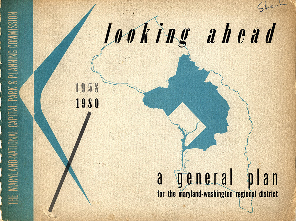
The cover of the first General Plan for the Maryland-Washington Regional District, which covered only 294 square miles in Montgomery and Prince George’s counties (dark blue area).
The region’s post-World War II employment growth spurred a significant subdivision activity in the county during the 1950s and 1960s. The Maryland-Washington Regional District—the official name of the M-NCPPC’s planning jurisdiction at the time—completed the first General Plan in 1957. This included parts of Montgomery and Prince George’s counties.
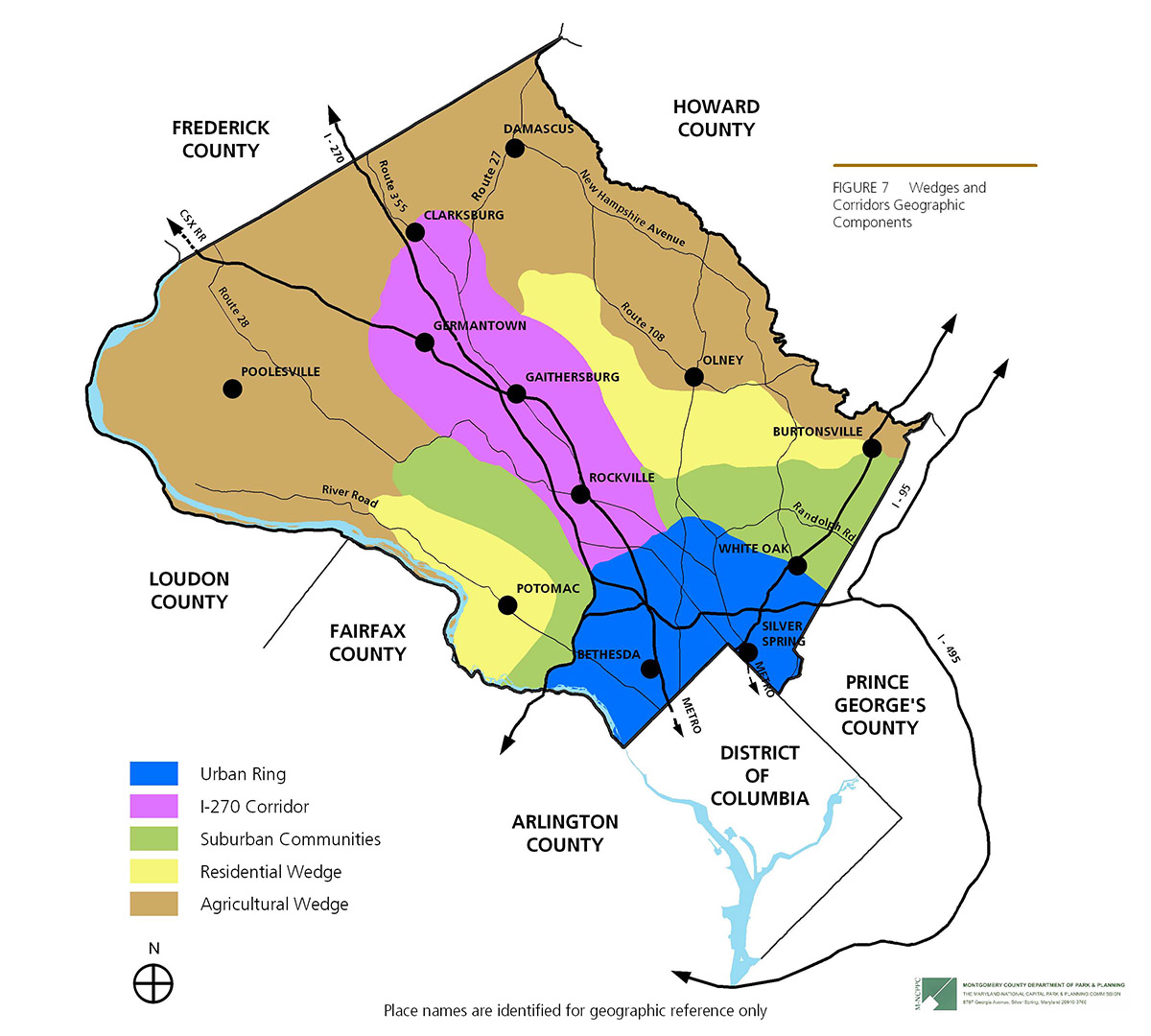
It was soon followed by the 1964 General Plan on Wedges and Corridors, which covered the entirety of both Montgomery and Prince George’s counties and set the foundation of land use and planning in Montgomery County for the next 50 years. Having acquired the legislative authority to approve all master plans in the county in 1966, the Montgomery County Council approved an update to the Wedges and Corridors Plan in 1969 but kept the basic Wedges and Corridors concept intact. While the Wedges and Corridors Plan was visionary, its implementation was constrained by the tools and mechanisms available at the time. It resulted in a land use pattern dominated by automobile and more than one-third of the county exclusively used for single-family homes.
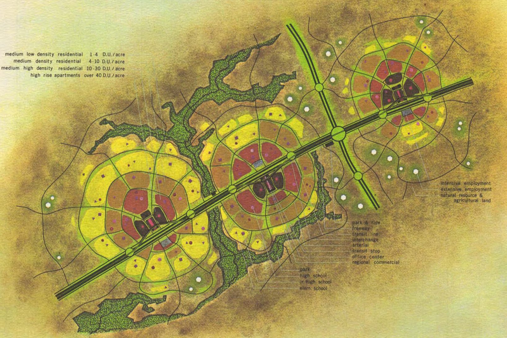
Corridor cities, as imagined by the 1964 Plan, were similar in some ways to the Complete Communities idea in the Thrive Montgomery 2050 Plan.
The first Metrorail station opens
The 1970s began with the approval of the Metro system; the coordination of planning for Metro; the establishment of Montgomery County’s four Central Business Districts (Bethesda, Friendship Heights, Silver Spring, and Wheaton); the elimination of several major transportation improvements called for in the 1964 General Plan (the Outer Beltway, the Northern Parkway and the extension of Metrorail along Route I-95); adoption of the Moderately Priced Dwelling Unit (MPDU) law; and the Adequate Public Facilities Ordinance (APFO). During the 1970s the county’s funding priorities went to Metrorail and Metro-related access roads, while numerous other road projects were cancelled or delayed due to two recessions and citizen opposition. In 1978, the first Metrorail station in Montgomery County opened in Silver Spring.
The building boom of the 1980s
The 1980s started with the creation of the Agricultural Reserve, the first of its kind in the country, and the first comprehensive Erosion and Sediment Control and Stormwater Management requirements in the county code. In this decade, the county saw the first efforts to revive downtown Silver Spring and the start of the county’s biomedical industry. Recognizing that academic institutions are integral to successful biotech communities, the county created a 288-acre park called Shady Grove Life Sciences Center. The county zoned the land for bio-medical research and development, and donated land and funds in the Life Sciences Center to Johns Hopkins University and the University of Maryland.
In 1986, concerned about too much development being approved during the building boom of the 80s, the Montgomery County Council enacted an Annual Growth Policy (AGP) for the County. Since then the Council has used AGP, now called the Growth and Infrastructure Policy, to direct the Planning Board’s administration of the APFO. At the same time, the county established an impact tax structure for Germantown and Eastern Montgomery County, which was expanded to Clarksburg in the 1990s, and to the entire county in 2002. These impact taxes were collected for transportation projects until 2003, when the Council approved a separate development impact tax for schools.
The revitalization of downtown Silver Spring
Planning for the revitalization of downtown Silver Spring started in the 1980s but took off in the 1990s. The 2000 Silver Spring Sector Plan created the blueprint for the revitalization of downtown core into a mixed-use walkable place. It required significant public investment such as the restoration of the Silver Theater, and attracted private development including the Discovery Communications headquarters and other residential and commercial developments. It is a great success story of the 2000s, which established Montgomery County as a leader in mixed use, transit-oriented development.
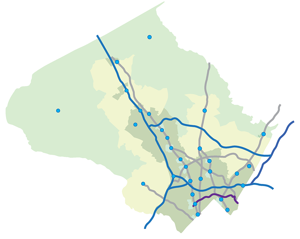
The success of Silver Spring in the 2000s was followed by another ambitious public-private partnership to revitalize White Flint in the 2010s. The implementation of Purple Line and a network of bus rapid transit (BRT) corridors starting in the 2020s is another milestone in the county’s evolution from farming to a suburban bedroom community to a more urban and diverse place of more than a million people.
Planning for the county’s next 50 years
Montgomery County is growing more slowly than in past decades, but our population is still projected to increase by about 200,000 people over the next 30 years. Disruptions from climate change, pandemics, automation, artificial intelligence, inequality, and economic changes at the regional, national, and global scale require us to rethink about the way we live and work. We face daunting challenges, but we can draw on our enviable human and physical resources. Through the update to the General Plan, Thrive Montgomery 2050, we can embrace new realities, address historic inequities, and shift the way we plan our communities to be more equitable, resilient, and sustainable.
Montgomery County has always responded to development pressures by adjusting its land use framework and creating new, and updating its existing, master plans. Today there are more than 60 local area master pans and county-wide functional master plans.
Key Planning Milestones
- 1927—The Maryland General Assembly established the M-NCPPC
- 1948—”Council-Manager” form of government, first home-rule county in Maryland
- 1954—End of legal school segregation in Brown v. Board of Education
- 1957—First General Plan for Montgomery and Prince George’s counties
- 1964—General Plan on Wedges and Corridors

1964 (Wedges and Corridors)
- 1964—Federal Civil Rights Act
- 1966—County Council authorized to approve master plans
- 1967—First mandatory erosion and sediment control requirements by the county
- 1969—General Plan Comprehensive Amendment
- 1973—Moderately Priced Dwelling Unit law
- 1973—Adequate Public Facilities Ordinance
- 1976—Locational Atlas of Historic Places
- 1979—Historic Preservation Commission established
- 1980—Agricultural Reserve and the Transfer of Development Rights program
- 1986—Annual Growth Policy
- 1992—Forest Conservation law

1993
- 1993—Limited General Plan Amendment
- 1994—Special Protection Areas
- 2003—School Impact Tax
- 2009— Climate Protection Plan Resolution
- 2010—The Purple Line Functional Plan
- 2013—County-wide Transit Corridors Functional Master Plan (BRT)
- 2014—Tree Canopy Conservation law
- 2014—Comprehensive Zoning Code Update
- 2017—International Green Construction Code
- 2018— Bicycle Master Plan

2020

About the author
Khalid Afzal is the co-project manager for Thrive Montgomery 2050. He has been with the Montgomery County Planning Department for more than 20 years working as a land use planner and an urban designer in both the regulatory and long-term planning sectors.
Jerry A. McCoy
Hi Mr. Afzal,
Can you please credit the first photograph in your article to “Willard R. Ross (1860-1948).”
Mr. Ross took this photo on June 21, 1917.
It appears on p. 16 of my 2005 book, “Historic Silver Spring.”
Thank you.
Jerry
Khalid Afzal
Hello Mr. McCoy,
I apologize for not including the proper attribution for the photo. It has been updated with the credit as you indicated. Thank you for catching this and providing the attribution.
Regards,
Khalid
David S Rotenstein
Can’t Montgomery County’s Planning Department write about Silver Spring history without amplifying the racist publications that erase the Black experience and that celebrate the white supremacists who founded the community? There are so many other images this author could have used without giving the Silver Spring Historical Society yet another bit of validation of its racially biased publications (e.g., the “Historic Silver Spring” book).
Robert Smythe
This brief characterization of development in and around Montgomery County should get a “Rosy Scenario” award. It omits the decades-long pattern of giving up open space to ambitious commercial developers with little or no consideration to the adverse impacts on traffic, noise, loss of trees and green space, and pedestrian safety. We don’t need to turn Bethesda and Silver Spring into sterile, barren glass-box cityscapes like Crystal City but that’s where we are headed.
Jennifer Sue Odintz
This article completely white-washes the history of our county. Calling MoCo a “farming community” erases the ugly history of plantations and enslaved people in our county. Then, there is no mention of the historic black communities that existed, nor the Historic African cemetery that was desecrated, buried in fill, and paved over on River Road. We can not plan an equitable future while hiding the truth of our past.
C P Zilliacus
it disappoints me that there is no candid mention of the 1981 Eastern Montgomery County Master Plan (covered the Cloverly, Fairland and White Oak Master Plan Areas) and its failed central theme, “a concept of transit serviceability.”
This document was superseded in the late 1990’s but the damage it did remains.
The 1981 plan is an example of what goes wrong when countywide priorities (including TDR receiving areas for the Ag Reserve; unquestioning reliance on transit service in suburban communities far from Metrorail; brown trout preservation; and too many people packed into garden apartment complexes) take priority over the individual needs of communities.