Upper Patuxent Area
Amendment to the Master Plan for Historic Preservation and Update to the Locational Atlas
 On September 18, 2012, the County Council approved with revisions the Planning Board Draft of Upper Patuxent Area Historic Resources, An Amendment to the Master Plan for Historic Preservation. On November8, 2012 and December 19, 2012 respectively, the Planning Board and the Maryland-National Capital Park and Planning Commission adopted the amendment as approved by Council. The approved and adopted amendment designates ten sites and one historic district on the Master Plan for Historic Preservation. View the Planning Board Draft (6.4 MB), the Council resolution showing approved revisions, the joint Planning Board/M-NCPPC resolution adopting the approved amendment, and the final status summary table, which shows the final status of the resources and tax parcels.
Once the approved and adopted amendment has been published, it will be posted here and available for viewing or purchase at the Planning Department’s Information Counter.
Overview
Rural resources on 95 tax parcels in northeastern Montgomery County and environs were evaluated for designation on the County’s Master Plan for Historic Preservation.
The resources were evaluated for their architectural and historical significance and public interest factors. Designations took the form of an amendment to the Master Plan for Historic Preservation. The resources were designated when the County Council approved the amendment and the Planning Board and M-NCPPC adopted it.
As part of the process, the Planning Board updated the Locational Atlas by adding and removing evaluated resources. The Locational Atlas is County’s list of resources with potential architectural and historic significance.
Resources on the Locational Atlas are afforded limited protections under the Historic Preservation Ordinance (Montgomery County Code, Chapter 24A: Historic Resources Preservation). Resources on the Master Plan for Historic Preservation are afforded broader protections, and may qualify for certain benefits and incentives, including tax credits.
Background
Lead planner Sandra Youla takes us on a tour of Upper Patuxent history in this Montgomery Plans excerpt.
Planners began the evaluation by identifying resources on the original 1976 Locational Atlas within the Upper Patuxent (Upper Planning Area 15) in northeastern Montgomery County. The Upper Patuxent is bounded by Frederick County and Parr’s Spring on the northwest; Howard County and the Patuxent River on the northeast; Hipsley Mill Road and Etchison on the southeast; and Kemptown Road, Ridge Road, Planning Area 11, Damascus Road, and Laytonsville Road on the southwest.
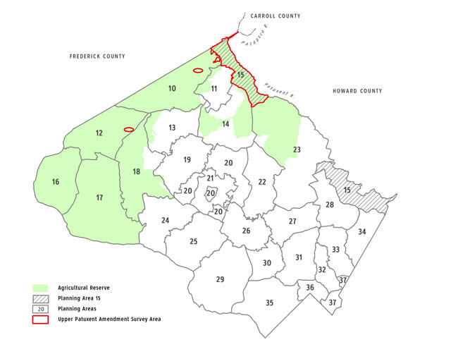 Upper Patuxent amendment survey area, Montgomery County, MD (View a detailed map (pdf, 3.2MB) of resource locations)
After surveying the area, planners included three potentially significant resources in the Upper Patuxent that were not yet on the Locational Atlas. They also included resources in Planning Area 10 near Clagettsville and others in Planning Area 14 near Etchison because they adjoined the Upper Patuxent and were related to it architecturally and historically. Two resources, one in Planning Area 10 and one in Planning Area 12, were included in the evaluation at the owners’ request. The vacant Upper Patuxent sites of two resources that had been physically relocated from the survey area (one to Frederick County and one to Planning Area 17) were included in the evaluation and removed from the Locational Atlas.
Planners then prepared detailed research forms for the resources to develop their historic and architectural context. In addition, they held a public information meeting and met with various citizens and citizen groups.
Subsequently, planners prepared draft amendments and staff reports for the consideration of the Historic Preservation Commission and Planning Board. The Historic Preservation Commission and Planning Board held public hearings and worksessions to evaluate the resources. Planners then prepared the Planning Board Draft amendment, which reflected the Planning Board’s recommendations and actions. The Planning Board Draft was reviewed by the County Executive, and the County Council held a public hearing. The Planning, Housing, and Economic (PHED) Committee and Council held worksessions. The Council approved the Planning Board Draft amendment with revisions, and the Planning Board and M-NCPPC adopted the approved amendment.
Project Schedule & Record
Meeting and events, along with a record of evaluations and supporting documents, are shown below.
Upcoming
- The Planning Department will publish the approved and adopted amendment.
Past
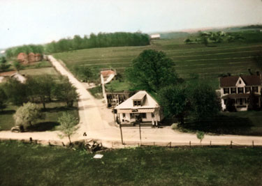 Etchison circa 1935 (Source: Steven Hawking.)
 December 19, 2012: M-NCPPC Adoption
November 8, 2012: Planning Board Adoption
October 9, 2012 and previously: DPS Notification
September 18, 2012: Council Action
September 11, 2012: Full Council Worksession
June 25, 2012: PHED Committee Worksession
June 12, 2012: Council Public Hearing
May 1, 2012: Council Announcement of Public Hearing
February 29, 2012: Planning Board Draft Transmittal to County Executive and County Council
Fall 2011: Planning Board Chair Review of Planning Board Draft
February 10, 2011: Planning Board Worksession #3
December 13, 2010: Planning Board Worksession #2
November 4, 2010: Planning Board Worksession #1
October 14, 2010: Planning Board Public Hearing
April 28, 2010: Historic Preservation Commission Meeting and Workession
April 14, 2010: Historic Preservation Commission Public Hearing
March 10, 2010: Historic Preservation Commission Worksession #3
February 24, 2010: Historic Preservation Commission Worksession #2
January 20, 2010: Historic Preservation Commission Public Hearing and Worksession #1
November 19, 2009: Public meeting
2006 – 2009: Resource survey and research
December 19, 2012: M-NCPPC Adoption
Download the M-NCPPC agenda, staff report, and M-NCPPC resolution.
The Maryland-National Capital Park and Planning Commission adopted M-NCPPC Resolution No. 12-26 (Planning Board Resolution No. 12-129) adopting the Upper Patuxent Area Amendment as approved by the County Council, sitting as the District Council, per Council Resolution No. 17-538. The approved and adopted amendment designates ten sites and one district on the Master Plan for Historic Preservation.
- Planning Board Draft (6.4 MB)
- Council resolution
- Final status summary table showing the final status of all evaluated resources and tax parcels
- Final status notification letters – designated resources (21.55 MB)
November 8, 2012: Planning Board Adoption
Download the Planning Board agenda, staff report, and Planning Board resolution.
![]() Watch the Planning Board consent item
Watch the Planning Board consent item
The Planning Board adopted Planning Board Resolution No. 12-129 adopting the Upper Patuxent Area Amendment as approved by the County Council, sitting as the District Council, per Council Resolution No. 17-538. The approved and adopted amendment designates ten sites and one district on the Master Plan for Historic Preservation.
- Planning Board Draft (6.4 MB)
- Council resolution
- Final status summary table showing the final status of all evaluated resources and tax parcels
October 9, 2012 and previously: DPS Notification
The Department of Permitting Services was notified on October 9, 2012 of the final status of all resources and properties under evaluation, so that DPS could update its list of properties on the Locational Atlas and the Master Plan for Historic Preservation. DPS was also notified previously, following Planning Board worksessions, of the status of evaluated resources.
- 10.9.2012 Notification to Department of Permitting Services – Final Status
- 7.27.2011 Notification to Department of Permitting Services
- 12.22.2010 Notification to Department of Permitting Services
September 18, 2012: Council Action
Download the Council agenda, packet, and Council resolution.
![]() Watch the Council action
Watch the Council action
The Council introduced and adopted Council Resolution No. 17-583, which approves the Planning Board Draft Amendment with revisions. The approved plan designates ten sites and one historic district on the Master Plan for Historic Preservation. The Council mainly differed from the Planning Board as follows:
- 10/1 Friendship – reduced the environmental setting to exclude the Kemptown Road master planned right-of-way within the parcel
- 15/05 Molesworth-Burdette Farm – reduced the environmental setting to 0.5 acres to include only dwelling house and summer kitchen/tenant house
- 15/8 Clagettsville HD – did not designate but instead designated as an individual site 15/08-1 Montgomery Chapel Methodist Protestant Church and Cemetery (three parcels and right-of-way )
- 15/16 Clagett-Brandenburg Farm and Tobacco House – did not designate, encouraged relocation of the tobacco house offsite for public viewing without use of public funds for the move
- 15/17 Sarah Brandenburg Farm – reduced the environmental setting to exclude the existing paving and the land to the northwest of this paving
- 15/20 Mt. Lebanon Methodist Protestant Church – added text stating that that the Planning Board should modify the master planned right-of-way for Damascus Road to avoid transportation/historic resource conflicts.
- 15/29 Etchison Historic District – added text stating that that the Planning Board should modify the master planned right-of-way for Laytonsville Road to avoid transportation/historic resource conflicts.
- 15/73 Basil Warfield Farm – reduced the environmental setting by excluding Damascus Road master planned right-of-way within the two parcels; however, from the southern boundary of the property at Damascus Road to 100 feet north of the tenant house, the environmental setting extends to the existing (2012) paving of Damascus Road.
- Planning Board Draft (6.4 MB)
- Final status summary table showing the final status of the resources and tax parcels
September 11, 2012: Full Council Worksession
Download the Council agenda, packet, and summary.
![]() Watch the Full Council worksession
Watch the Full Council worksession
- Planning Board Draft (6.4 MB)
June 25, 2012: PHED Committee Worksession
Download the PHED agenda and packet.
![]() Listen to the PHED Committee worksession
Listen to the PHED Committee worksession
- Planning Board Draft (6.4 MB)
- Summary table of resources, tax parcels, and Planning Board actions
June 12, 2012: Council Public Hearing
Download the Council agenda, packet, and summary
![]() Watch the Council public hearing
Watch the Council public hearing
- Planning Board Draft (6.4 MB)
- Summary table of resources, tax parcels, and Planning Board actions
May 1, 2012: Council Announcement of Public Hearing
Download the Council agenda, packet, and summary
![]() Watch the Full Council worksession
Watch the Full Council worksession
February 29, 2012: Planning Board Draft Transmittal to County Executive and County Council
Download the Planning Board Draft .
The Planning Board transmitted the Planning Board Draft Amendment to the Master Plan for Historic Preservation: Upper Patuxent Area Historic Resources to the County Executive and County Council on February29, 2012. The Planning Board Draft contains the results of the Planning Board’s evaluation, maps, project context, an area history, a list of resources for future evaluation, and a summary table of evaluated tax parcels and resources.
The Planning Board recommended that two districts and 10 sites be designated on the Master Plan for Historic Preservation, that 19 sites not be designated, and that staff and the County Council take up the issue of design guidelines for one of the districts. The Planning Board updated the Locational Atlas by adding three sites recommended for designation; removing 18 of the 19 sites not recommended for designation; and removing 23 parcels that the Board excluded from the two historic districts that it recommended for designation. The Board also asked for the County Council’s recommendation to retain one of the resources on the Atlas if not designated and noted that the Atlas would be updated as necessary following the County Council’s evaluation.
- Summary table(pdf) of all resources, tax parcels, and Planning Board actions,
- Districts and sites recommended for designation by Planning Board,
- Sites not recommended for designation by Planning Board,
- Planning Board Draft comments from the Executive Branch (04/23/2012) (pdf)
Fall 2011: Planning Board Chair Review of draft Planning Board Draft
The Planning Board Chair reviewed the draft Planning Board Draft in lieu of a final worksession.
February 10, 2011: Planning Board Worksession #3
Download the staff report specifying properties and resources under consideration
![]() Watch the worksession
Watch the worksession
The Board finalized its recommendations for the Planning Board draft of the Upper Patuxent amendment. At the worksession, the Board evaluated five individual sites for which the HPC and staff differed on whether to designate and recommended:
- designating Parr's Spring (15/1) and Mt. Lebanon School, site of Mt. Lebanon Methodist Protestant Church (15/117)
- not designating the Alfred Baker House (15/4)*, the Colonel Lyde Griffith/Merhle Warfield Farm (15/27)* and the Luther W. Moore Farm (15/28).
* The Board removed these resources from the Locational Atlas
December 13, 2010: Planning Board Worksession #2
Download the staff report specifying the properties and resources under consideration
![]() Watch the worksession
Watch the worksession
In Clagettsville, the Planning Board recommended designating a 34-parcel historic district, which excludes all parcels north of Moxley Road (28500, 28505, 28510, 28514, 28515, 28520 Kemptown Road and 9915 Moxley Road), plus the three parcels south of Moxley Road (28130, 28218, and 28320 Kemptown Road).The Planning Board also removed the excluded parcels from the Locational Atlas.
In Etchison, the Planning Board recommended a five-parcel district that is identical to the district recommended by the Historic Preservation Commission, including 6920, 7000, 7004, and 7010 Damascus Road, and 24220 and 24221 Laytonsville Road.The Planning Board removed from the Locational Atlas 13 parcels it did not recommend for inclusion in the Etchison Historic District.
November 4, 2010: Planning Board Worksession #1
Download the staff report specifying the properties and resources under consideration
![]() Watch the worksession
Watch the worksession
The Board considered sites for which the HPC and staff concurred on whether to designate. The Planning Board :
- Removed 16 sites from the Locational Atlas and recommended that the sites not be designated on the Master Plan for Historic Preservation: John Moxley House (10/3), John D. Purdum House (10/5), Burdette-Riddle Farm (10/18), James Lauman House (12/10), Matthew Molesworth House (15/2), Rezin Moxley House (15/3), Becraft Farm (15/6), Brown's Tobacco House (15/7), Captain Clagett-Hilton Farm (15/9), Thompson-Woodfield Farm (15/12), Mullinix Store site (15/14), Warthan-Day Farm (15/19), John O. Etchison House (15/21), Wilson Warfield Farm (15/24), Fred Watkins House (15/26), and log barn site (15/30).
- Added two sites to the Locational Atlas: Chrobot House (Margaret Price House) (15/71), and Basil Warfield Farm (15/73).
Recommended that those two sites and six others be designated on the Master Plan for Historic Preservation: Friendship (10/1), Molesworth-Burdette Farm (15/5), Shipley-Mullinix Farm (15/13), Clagett-Brandenburg Farm and Tobacco House (15/16), Sarah Brandenburg Farm (15/17), Mt. Lebanon Methodist Protestant Church and Cemetery (15/20).
October 14, 2010: Planning Board Public Hearing
The public hearing draft contains the Historic Preservation Commission’s recommendations on whether certain historic resources should be designated on the Master Plan for Historic Preservation and added to, removed from, or retained on the Locational Atlas. Four people testified.
- Watch thepublic hearing
- View a summary of the testimony and public written testimony
- View the staff report
- View the Public Notice: Planning Board Public Hearing, October 14, 2010 and the Notice to Property Owners and Interested Parties: Planning Board Public Hearing
- View the list of resources recommended by the HPC and the HPC testimony
- View the Designation Criteria
April 28, 2010
- Summary of all Historic Preservation Commission Worksessions Meeting
The HPC completed its evaluation of 38 historic resources, including 36 individual resources and two historic districts. The HPC recommended that:- 15 resources (one historic district and 14 individual sites) be designated on the Master Plan for Historic Preservation and that two of these not already on the Locational Atlas be added to it
- 22 resources (one historic district and 21 individual sites) not be designated and that 21 of these be removed from the Locational Atlas (one was a non-Atlas property)
- one resource be retained on the Locational Atlas
The HPC recommended the Etchison Historic District consist of five parcels: 7010 Damascus Road, 7004 Damascus Road, 7000 Damascus Road, 24230 Damascus Road, 24220 Laytonsville Road, 24221 Laytonsville Road, and 6920 Damascus Road. - Historic Commission worksession/Clagettsville and Etchison resources
The resources and the HPC's recommendations are noted below. (The HPC also reconfirmed its vote, taken on 1/20/2010, to recommend removal of 16 historic resources from the Locational Atlas in recognition of changes to the membership of the HPC.)
View the Final List of Resources Evaluated by HPC (Link to table of resources)
View the meeting agenda (pdf, 18KB)
View the staff report (pdf, 1MB)
Learn more
April 14, 2010: Historic Preservation Commission Public Hearing /Clagettsville and Etchison resources
View the staff report
The public hearing was held as part of the Commission's consideration of the Staff Draft Amendment to the Master Plan for Historic Preservation: Upper Patuxent Area Resources. Five people testified.
March 10, 2010: Historic Preservation Commission Worksession #3
View the Staff Report
The HPC took the following actions:
- Sarah Brandenburg Farm (15/17), 26301 Mullinix Mill Road: Recommended designation
- Mt. Lebanon Methodist Protestant Church and Cemetery (15/20), 8115 Damascus Road: Recommended designation
- Col. Lyde Griffith/Merhle Warfield Farm (15/27), 7305 Damascus Road: Recommended removal from the Locational Atlas
- Luther Moore Farm (15/28), 7201 Damascus Road: Recommended designation
- Chrobot House (Margaret Price House) (15/71), 24724 Hipsley Mill Road: Recommended listing in the Locational Atlas and designation
- Basil Warfield Farm (15/73), 8201 and 8251 Damascus Road: Recommended listing in the Locational Atlas and designation
- Mt. Lebanon School and Site of Mt. Lebanon ME Church (15/117), 26130 Mullinix Mill Road: Recommended removal from the Locational Atlas
February 24, 2010: Historic Preservation Commission Worksession #2
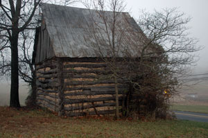 The Clagett-Brandenburg Farm tobacco house is one of the last intact log tobacco barns in Montgomery County.
View the Staff Report
The HPC took the following actions:
- Friendship Farm (10/1), 28110 Ridge Road: Recommended designation
- Parr's Spring (15/1), 4704 Baltimore National Pike: Recommended retention in the Locational Atlas pending further study
- Alfred Baker House (15/4), 28901 Kemptown Road: Recommend removal from the Locational Atlas
- Molesworth-Burdette Farm (15/5), 28600 Ridge Road: Recommended designation
- Shipley-Mullinix Farm (15/13), 27001 Long Corner Road: Recommended designation
- Clagett-Brandenburg Farm and Tobacco House (15/16), 26360 Mullinix Mill Road: Recommended designation
- Clagettsville Historic District (15/8): Recommended removal from the Locational Atlas and identified six resources for evaluation as individual sites:
- Montgomery Methodist Church, 28201 Kempton Road
- Ira Dorsey Moxley House, 28318 Kempton Road
- Robert B. & Susan Moxley House, 28322 Kempton Road
- Lewis and George Easton House, 28408 Kempton Road
- Ollie & Tressie Moxley House, 28411 Kempton Road
- Ollie & Lelia Moxley Farm, 28515 Kempton Road
- Etchison Historic District (15/29): Recommend designation with revised boundaries (see 2.24.10 staff report, option 3) and identified two resources for evaluation as individual sites:
- Mt. Tabor Methodist Church, 24101A Laytonsville Road
- Walter and Ida Allnutt House, 6920 Damascus Road
January 20, 2010: Historic Preservation Commission Public Hearing and Worksession #1
The HPC unanimously approved the staff recommendation, finding 16 resources failed to meet the criteria for architectural or historical significance and recommending that the Planning Board remove these 16 resources from the Locational Atlas.
- Public Notice: HPC Public Hearing and Work Session, January 20, 2010
- Memo to property owners and interested parties
- Staff Draft Amendment to the Master Plan for Historic Preservation: Upper Patuxent Area Resources
- Staff recommendations: 15 resources recommended for designation, 16 resources recommended for removal from Locational Atlas
- Staff Report for the HPC
- Staff presentation to the HPC
- Items received for the public record (as of January 20, 2010)
- Items received for the public record (as of February 16, 2010)
November 19, 2009: Public meeting
Preservation planners held a public meeting at the Damascus Recreation Center to discuss Montgomery County's historic preservation program and provide an overview of the ongoing evaluation of Etchison, Clagettsville and area properties for possible designation in the County's Master Plan for Historic Preservation.
2006–2009: Resource survey and research
View Research Forms for each resource
Planners surveyed resources in Planning Area 10 and Upper Planning Area 15, and parts of Planning Areas 12 and 14. They then prepared a detailed research form for each resource with initial architectural and historical information.
- Letter to Locational Atlas Property owners 11.15.2006
- Letter to Clagettsville Historic District Property Owners 11.15.2006
- Letter to Etchison Historic District Property Owner s 11.28.2006
- Letter to Owners and Residents 11.01.2007
M-NCPPC Staff Contact
Sandra Youla, Senior Planner / Historic Preservation
301-563-3400
Sandra.Youla@montgomeryplanning.org
Clare Kelly, Research & Designation Coordinator
Clare.Kelly@montgomeryplanning.org